
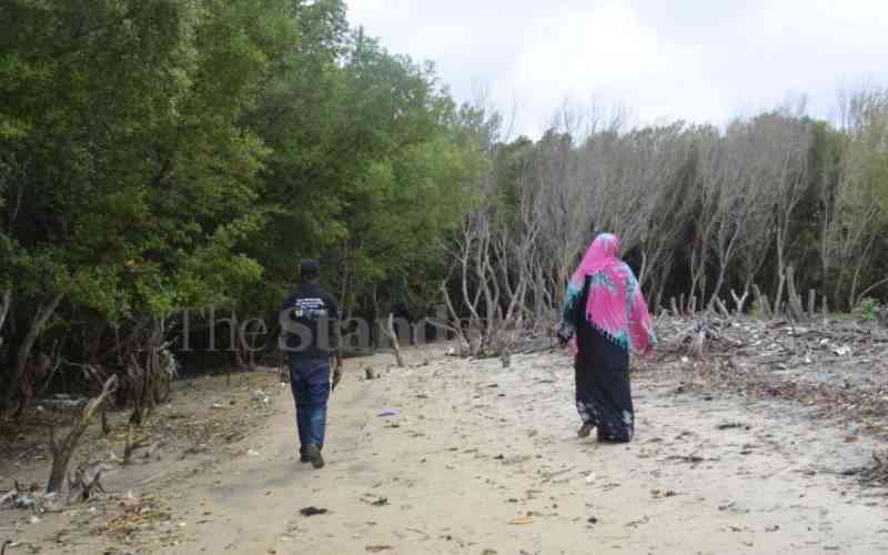
Standing on the ruins of a once affluent beach hotel at Kipini, Riziki Bwanake can barely tell where the last structure of the expansive facility stood.
Only the debris that have been recently washed away into the sea tell the story of a village whose shoreline has been eroding over the years.
It is here where River Tana, the country's longest river, empties into the Indian Ocean.
"Kipini was beautiful. It still is. However, the shoreline has been eroding so fast and washing away huge chunks of land. This is not good. We must act now," says Ms Bwanake.
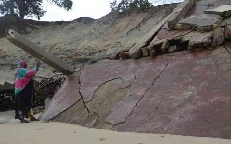
The last of River Tana Lodge's 10 buildings, which were spread out amply within the quarter-acre piece of land in the North Coast, fell in 2020.
Although there are no recent studies showing the extent of degradation, the villagers are afraid the sea and its waves will find way into their homes.
Many understand the value of mangroves.
A member of the Kipini Community Forest Association, Ms Bwanake is among those who have lived to witness and tell tales of towering buildings tumbling. He childhood memories are still fresh with activities that happened on spots that are now deep into the sea.
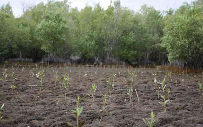
They are now banking on mangrove conservation to build resilience along the Coast.
"We're restoring degraded areas and working with government agencies such as the Kenya Forest Service (KFS) to keep off those illegally felling mangroves for poles and firewood," she says.
"These mangroves, we believe, will address part of the challenges we are witnessing here in Kipini, including erosion of the shoreline."
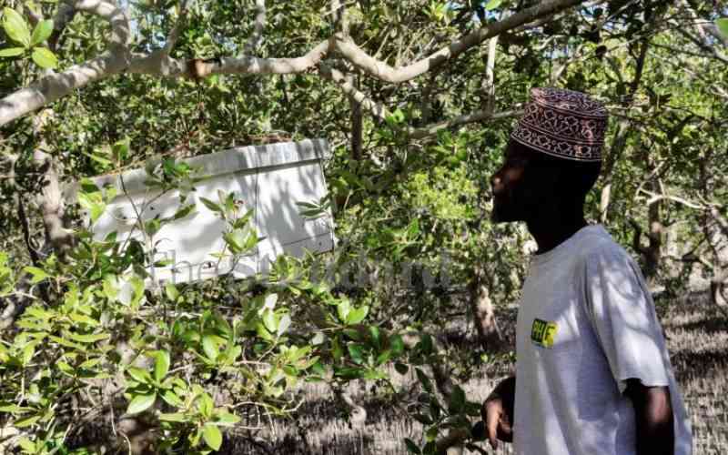
Close to 200 kilometres away, in the neighbouring Kilifi County, Khamis Omar has made it his duty to keep an eye on illegal activities around Mida Creek.
Mida Creek is a tidal inlet that stretches across 32 square kilometres, and hosts seven out of the nine species of mangrove found in the country.
"We have to protect these forests and keep the environment clean. We often conduct clean-ups during which we have collected a lot of plastic bottles and old fishing nets," he says.
"We receive a lot of visitors, including researchers, tourists and students, who come to learn about mangroves. As a fisherman, I know what it means to protect the breeding areas in the mangroves. It means more catch and more money."
Mangrove forests in Kipini and Mida are part of mangrove forests in the country, covering 61,271 hectares. This is about three per cent of Kenya's natural forest cover, according to the Ministry of Environment and Forestry.
These forests are common features in protected bays, deltas, creeks, river estuaries and lagoons. They grow in the five coastal counties - Lamu, Kwale, Mombasa, Tana River and Kilifi - and are distributed along the 600-kilometre coastline.
According to the National Mangrove Ecosystem Management Plan, all the mangrove trees recorded in the Western Indian Ocean region are in Kenya.
Rhizophora mucronata (mkoko) and Ceriops tagal (mkandaa) are the dominant species of mangrove trees, making up 70 per cent of the formation. Other species include Avicennia marina (mchu), Bruguiera gymnorrhiza, (muia) Sonneratia alba (mlilana), Xylocarpus granatum (mkomafi), Lumnitzera racemosa (kikandaa) Xylocarpus moluccensis (mkomafi dume) and Heritiera littoralis (msikundazi).
Research has shown that mangrove forests are important in protecting shorelines and reducing erosion, protecting land and coastal communities from storms.
Together with sea grass, they provide critical habitat for aquatic organisms. They also provide important nursery areas for many coral reef fishes.
Although the use of mangroves as wood fuel is not considered a major threat, logging of mangroves for the construction of canoes, fences and houses remains a big threat.
The trees, which are known to be salt-tolerant, play an important role in global climate regulation. They store up to 1,000 tonnes of carbon per hectare, making them some of the most carbon-rich ecosystems.
Julie Mulonga, the director of Wetlands International Eastern Africa, says mangroves are the under-appreciated natural solution to the climate emergency.
"They can hold up to five times more carbon than terrestrial forests per hectare, enhancing climate resilience with their storm and flooding absorption potential," says Ms Mulonga.
"if we are going to unlock mangroves' full potential, we need to scale up the collection and analysis of data. We need to enhance conservation, which requires all hands on deck; decision-makers, scientists, and local communities."
Like in Kipini, most mangrove forests are under threat of unsustainable exploitation, tourism development and large-scale infrastructure such as the Lamu Port-South Sudan-Ethiopia-Transport (Lapsset) project.
The Lapsset Corridor Project is a regional infrastructure programme dedicated to interconnecting the East African countries - Kenya, Ethiopia and South Sudan. Kenya is spearheading the implementation of the project and although it received approval and Environmental Impact Assessment Licences from the regulatory bodies, some conservationists raised concerns.
It is expected that a large acreage of mangrove forests along the Indian Ocean might be cleared to pave the way for ports.
The latest data from the Ministry of Environment and Forestry indicates that Lamu County hosts approximately 37,650 hectares of mangrove forest in the country, translating into 61 per cent of the total mangrove forest cover. Kilifi has 8,536 hectares, while Kwale has 8,354 hectares.
Mombasa County has 3,771 hectares, or six per cent of the total mangrove forest cover, while Tana River has 3,260 hectares.
The ministry estimates that the country lost about 20 per cent of its mangrove cover between 1985 and 2009, translating to 450 hectares of mangrove forest lost per year.
Tana Delta Restoration Initiative project manager, George Odera, notes that mangrove habitats are being converted to create spaces for salt farms.
"There are also incidences of private salt farms releasing toxic wastes, mostly hyper-concentrated salty water, back into the sea," he says.
Such highly concentrated water kills fish and mangroves along its way.
The latest incident, says Mr Odera, was recorded in May at the Katsangani Creek in Tana River County where sizable tracts of mangrove forests were destroyed. The matter was taken up by the National Environmental and Management Authority (Nema).
According to environmental experts, climate change is also to blame for the drying up of some plantations.
This happens when the fresh water from rivers that neutralizes the hypersaline seawater begins to dwindle.
"Drying up of rivers draining into the ocean as well as dwindling volumes lead to a hypersaline environment, which mangroves cannot stand. They end up drying because of too much salt," explains Francis Kagema, Coast Regional Coordinator for Nature Kenya, a conservation organisation.
Fresh water from rivers, he adds, is key for the health of mangroves.
"This is an emerging threat which cannot be ignored even as impacts of climate change continue taking a toll on freshwater flow into the ocean."
While experts warn that the effects of climate change on mangrove forests remain critical and under-researched, siltation and pollution remain a serious concern.
Poor farming practices and clearing of forests upstream has seen soil being swept downstream into the ocean. Large amounts of soil is deposited along creeks and canals where mangroves grow. This creates what looks like isolated islands. In most cases, the mangroves dry up.
Although single-use plastic bags were banned in Kenya in 2017, the lack of disposal mechanisms for old and torn fishing nets coupled with huge amounts of plastic bottles that find their way into the ocean has remained a problem. They choke mangrove roots.
Many groups that have been involved in clean-up exercises burn the bottles and old nets because they lack proper disposal mechanisms.
"It is an issue that requires attention because burning them is still harmful," says Mr Kagema.
At Kipini where River Tana enters the ocean, effects of siltation and pollution are visible. Some mangrove trees stand on what looks like isolated islands with roots tangled on plastic papers and old nets.
"These are not islands but deposits of soil being washed downstream. You can also spot the old nets and huge amounts of plastics which are trapped in here," says Mr Odera
The drying up of some of the mangroves, as a result, gives a lee-way to people to fell the already drying trees for poles and firewood.
A 2018 report on forest resources management and logging indicated that at least 40 per cent of mangroves across the coast are degraded.
In Mombasa, it is estimated that 1,850 hectares of mangrove areas are degraded, which translates to 49 per cent of the total area under mangroves in the county. In Kwale, 3,725 hectares (44.6 per cent) of the total area under mangrove is degraded.
In Lamu, another 14,407 hectares are degraded while in Kilifi, 3,422 hectares of mangroves are degraded.
[This story was produced with support from the Internews' Earth Journalism Network]