Nakuru sitting on time bomb as fissures emerge after heavy rains

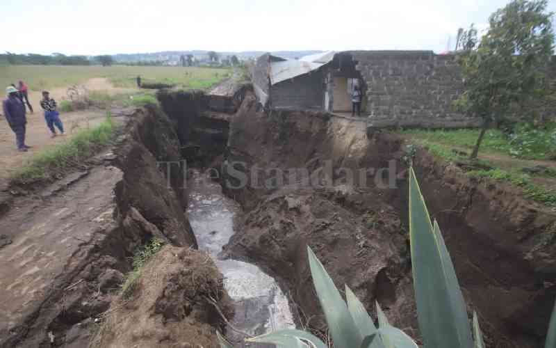
A collapsed house due to fault lines that emerged at Kaptembwo Estate in Nakuru West following heavy rains on May 16, 2024. [Kipsang Joseph, Standard]

The recent heavy rains have caused fears among a section of residents in Nakuru City and its environs following the emergence of fissures and fault lines.

A number of geologists and earth experts have raised the red flag.

They have pointed out that a large part of the city sits on fissures that pose a danger to human life and the development of real estate.

The experts argue that Nakuru City sits on unstable soil structure and fault lines resulting from volcanic activity that took place thousands of years ago.

The emergence of the fissures, which experts describe as a ticking time bomb, put the county government into sharp focus, considering that the past administration had formed a team to study the phenomena and submit a report which would guide human settlement and development of property in the area.

Immediate former governor Lee Kinyanjui, constituted a team comprising geologists and other experts from the Geothermal Development Company (GDC) and the Kenya Electricity Generating Company (KenGen), among other bodies, in 2020 following similar incidents in parts of the town.

Kinyanjui, while launching the team headed by Engineer Paul Njoroge of KenGen, said the county government would not allow residents to continue constructing houses along the fault lines.

He said the team’s report would enable his administration to beacon areas susceptible to fissures and also enable it to make informed decisions before approval for building plans was granted.

Following recent rains, residents of Kiamunyi, Kaptembwo, Ngata, Kiambogo and Kapkures areas have witnessed an emergency of huge fissures that have split their farms and residential plots, posing a danger to their lives and houses.

A number of houses in the Kaptembwo area where the fissures occurred also developed huge cracks on their walls, compromising their structural integrity.

Most of them were forced to vacate their homes and are now calling both the national and county governments to establish the extent of the menace to ensure their safety.

Nakuru Town West MP Samuel Arama, who visited the Kaptembwo area, called on the county government to deploy a team of experts to the area to study the enormity of the problem and advise the residents accordingly.

Mwangi Gichuki,  a Hydrologist said the soils in the region were not well compacted as they were formed due to volcanic activity.

Gichuki, who is a former MP for Ndaragwa and owns a borehole drilling firm, said massive flood waters have been causing erosion in the porous soils, which weakens the ground.

“That is why the grounds sink whenever it rains heavily, as the soil is already soaked with water and is unable to withstand their huge weight,” Gichuki said.

He added: “Since the soil texture is very porous and not well compacted or consolidated, water, which is soaking into the ground, adds additional weight, causing cracks that eventually develop into huge fissures.”

Gichuki said in most cases, fissures run parallel to the fault lines, given that the areas affected are on the foot of the Menengai Crater.

He added that sections of Nakuru’s Central Business District (CBD) were also sitting on fissures “ but most of the water do not sink into the ground as it normally flows into the drainage system which eventually drains it into Lake Nakuru.”

Gichuki further stated that most Nakuru residents were aware that buildings had been shaking whenever a huge lorry passed nearby, an indication that the ground was not firm.

He added that a number of boreholes have been collapsing during drilling due to loose soil structures, forcing drillers to incur huge costs to install casing.

“There are places in Nyandarua where you install casing for less than 50 metres going down, but in Nakuru, you are forced to install casing for the whole borehole measuring up to 150 metres or more,” Gichuki added.

Since the colonial era, the government had put a limit on the construction of story buildings within Nakuru City and its environs to four story, which has been flouted over the years. 

Another hydrologist, Francis Muthami, said Nakuru Town was sitting on unstable ground, due to volcanicity around Menengai Crater. Eng Muthami said although Menengai Crater was extinct, the region, which is in close proximity, has been experiencing minor tremors due to earthquakes, which constantly affect stability of the ground.

“The fault lines which were formed by volcanicity serve as a conduit for water sipping into the ground, which further weakens the stability of the ground by interfering with groundwater dynamic,” Muthami added.

He called on the government to map out the region and establish the areas affected by underground fault lines in order to guide residents which constructing buildings.

“The government also needs to ensure no buildings are constructed in certain areas once the fault lines have been located. Previously, we had rules which barred residents from constructing high-rise buildings within the town centre and surrounding areas,” Muthami said.

An article published in the Journal of Mountain Science states that Rift Valley was relatively prone to underground erosion ground fissures.

The article entitled; “Formation and Development of Underground Erosion Ground Fissures in the Rift Valley,” published in April 2022, states that water follows certain infiltration paths which end up affecting the stability of the ground.

Another article by a research student at the University of Nairobi, Isaac Kiprono Kanda,  states that the geology of the Nakuru area is comprised mainly of volcanic soils and rocks (lava and pyroclastic ) of tertiary-quaternary age, which has been affected by a series of faulting and are overlain by recent sediments.

Kanda’s findings were contained in a dissertation submitted to the University’s College of Biological and Physical Sciences for the award of a Master’s degree in Applied Geochemistry in March 2010.

In 2007, the Department of Mines and Geology submitted a report to the now-defunct Municipal Council of Nakuru on fault lines and fissures within the town and its environs.

The report was prepared by the government geologists to guide municipal officials when approving building plans within different parts of the town.

The municipal council also developed a Building and Construction Standard and Code (BCSC) and regulations, which recommended the construction of low-story buildings of less than four floors, which has now been disregarded.