Accurate maps to guide human settlement and conservation in Eastern Mau

Sensitisation process in Eastern Mau Forest block (PHOTO: Courtesy)

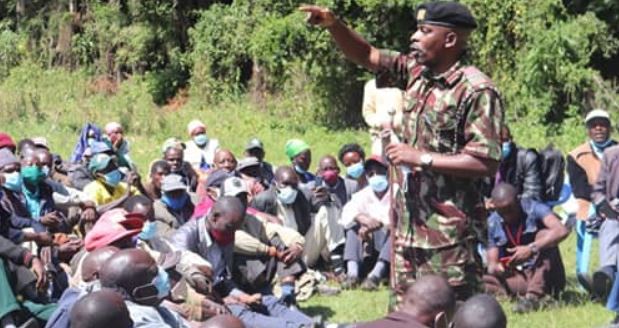
NAIROBI, KENYA: The Government multi-agency team tasked with the resettlement and boundary survey of the Eastern Mau Forest block has conducted a community sensitisation meeting in Nessuit location centred on articulating the ongoing titling process.

The exercise was led by Special Deputy County Commissioner Donald Mwiwawi (Chairperson) and KFS Head of Survey and Mapping Evans Kegode. The main aim of the Baraza was to inform the community on the current phase of the survey process and the status of the exercise hence ensuring public participation.

Mr. Mwiwawi noted that the previous maps used in the exercise had errors which led to conflicts among the community members. He assured the community of the preciseness of the exercise and the development of suitable and accurate maps that will guide human settlement and conservation for current and future generations.

He also urged the community to protect the environment and ensure they allocate 10 per cent of the allocated land for tree planting.

Meanwhile Cheptais Operations Camp has managed to reclaim 4,000 Ha of forest land that had been encroached in six months.

The Chief Conservator of Forest (CCF) Mr. Julius Kamau revealed during a visit to the Kenya Forest Service Rangers deployed in operations camps at Cheptais in Mount Elgon region, Embobut forest in Elgeyo Marakwet, and Nkopen in Maasai Mau forest to interact with frontline officers.

He noted that the process was also conducted in a human rights-based approach and saluted the officers for exercising tolerance while undertaking their discourse.

"KFS has registered immense success over the past year through the efforts of our front liners, who are you our Forest Rangers out here in the field. And for that, I am truly grateful," noted Kamau.

In Embobut forest, Kamau noted the operations camp has secured over 21,022 Ha of the forest since the start of the operation. He noted that the forest which forms Chesoi and Kapyego forest stations is a critical water catchment forming the basin which serves Eldoret and environs with water, as well as draining its water to Kerio Valley serving Lake Turkana, and also by large Lake Victoria basin to the West of Kenya hence the need to preserve, and reclaim the forest ecosystem.