Mt Elgon village where hundreds visit to read a traditional 'rain gauge'

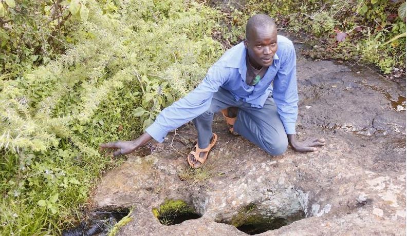
Joseph Kwemoi, a resident in Mt Elgon showing a rock that has features of traditional rain gauge at Chemweisus, Mt. elgon in Bungoma County’ [Benjamin Sakwa/Standard]

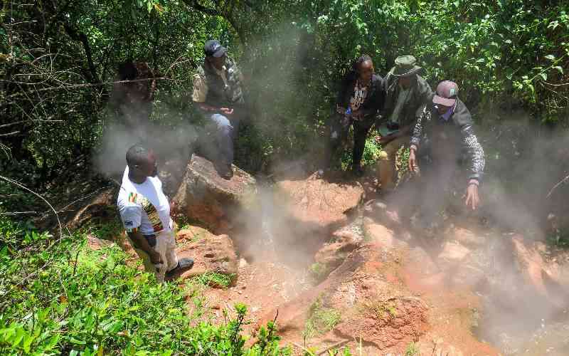
For many years, residents of Kapsokwony in Mount Elgon have trusted the oldest indigenous rock in the area to predict weather patterns.

The huge flat rock has never failed to give accurate weather predictions.

The rock bears three natural distinct holes set out in a straight line that resemble a spirit level (tool used by masons and builders).

Jared Wanyama, 55, from Kitale in Trans Nzoia, is among those who frequent the site and vouches for the rock’s predictions.

“My grandfather used to visit this area and would tell us a lot of things about it. He had a special attachment to this rock,” Wanyama told The Standard at the site.

Some visitors from Uganda had just left the site on this day.

“They were 15 farmers who wanted to ‘read’ the rock and maybe predict how long the long rains would last,” said Florence Lukoye, a resident.

Ms Lukoye said children are forbidden from playing around the rock because they can mess up its efficacy by inserting objects into the holes.

Andrew Cheserek from Chepyuk described the rock as godsend.

“I believe God intended to communicate to us directly on issues concerning climate through this rock because it has been here for many years,” said Mr Cheserek.

Experts believe characteristics exhibited by the rock are not strange.

“It just explains the usual weather forecast, usually, we have underground water whose level vary from one season to another explaining the behaviour of the rock,” said Noah Eledi, the Bungoma County director of meteorology.

Usually, one of the three holes has water throughout, but the second and third remain empty when rains are not expected and start showing a rise in level of water to indicate approaching rainfall.

“When you see water in the second hole, it signals approaching rains and once the third hole is full, heavy downpour follows in less than three days,” said Joseph Kwemoi, a resident.

According to Mr Kwemoi, residents start preparing their farms once the second hole fills to the brim and water trickles to the third hole.

Once the three holes are completely filled and spilling over, the rains fall. This, according to the residents, has never failed them in predicting the onset of heavy rains.

Heavy rains

Conventional weather tools are designed to work in a different manner.

“Based on the behaviour of this rock, farmers are advised when to plant and those living around Mount Elgon are advised to move to higher ground ,” said Kwemoi.

Here, it is the word of the weatherman against the indicators of the revered rock.

According to Polycarp Waswa, a village elder from Kapsokwony, locals believe the rock gives them precise results because it was used by their forefathers to monitor weather patterns.

“It is possible to tell when to expect heavy rains or drought by simply monitoring the behaviour of the holes,” he said.

Many a times, visitors come from far to ‘read’ the rock and relay feedback to their people about the kind of weather to expect.

During the infamous 1997 dry spell, hundreds of farmers from Trans Nzoia, Busia, Kakamega, Busia and even neighbouring Uganda visited the site in search of answers from the ‘marvelous’ rock.

Among the visitors are researchers, clerics, tourists as well as curious ordinary folk.

Just like the rainmakers of Nganyi in Vihiga County, who rely on the croaking of a frog and movement of termites to predict weather, generations of the Sabaot, Ogieks and other communities living in Mt Elgon rely more on the rock’s three holes.

Sow seeds

Many a times, elders would be assigned to monitor the rock and advise communities to prepare their land and sow their seeds in preparation for seasonal rains.

Usually, such feedback would be relayed during ceremonies, public meetings or from person-to-person. Sometimes, vernacular radio stations are used to disseminate the information.

According to Mr Eledi, the occurrences observed are a result of changes in the level of underground water.

The expert points out that underground water levels could rise or decrease whenever it rains even in faraway places or during the dry spell.

“The holes in the rock may not have water during the dry spell but will start filling up gradually when rains are experienced in neighbouring countries, because ground water flow is not localised,” Eledi told The Standard.

By the time the rains are closer home, the three holes could easily fill up “a clear pointer to either short or long rains.”

He said his department has been working closely with indigenous people to come up with a detailed weather forecast report. “We infuse both scientific approach and the traditional knowledge to come up with concrete weather forecast reports,” he said.