Study: Lake Turkana may survive but the people close by will suffer

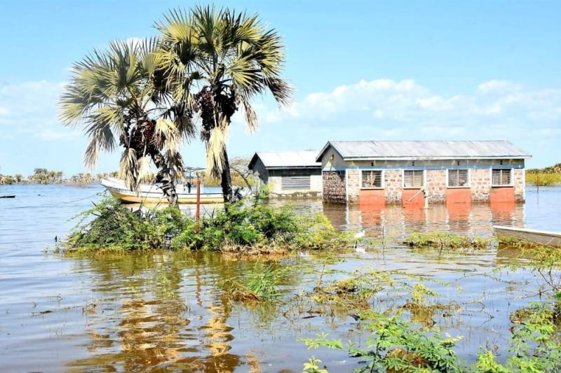
Beach management offices submerged by the flooding in Lake Turkana in September 2020 [File, Standard]

For years, Lake Turkana appeared as though it was drying up.

This is because Ethiopia has built a series of hydroelectric dams on its main tributary, the Omo River, leading to predictions of Lake Turkana’s demise as the water levels were forecast to drop by two-thirds.

But a new study from the United Nations Environment Programme (UNEP) predicts a far wetter future for Lake Turkana — the world’s largest desert lake in an arid part of northern Kenya — and possibly a more perilous one for the 15 million people who live on its shores.

According to the report titled, Support to Sustainable Development in Lake Turkana and its River Basins, published this month, over the next 20 years, climate change would likely lead to heavier rains over Lake Turkana’s river inflows, which would raise water levels in the lake itself and increase possibility of severe flooding.

“Simulations for the next 20 years predict that climate change may result in a marked increase in inflow to Lake Turkana, primarily from the Omo River, but also increased inflow from Kerio and Turkwel rivers.

"Such a possible increase in inflow will result in an increasing water level in Lake Turkana,” the report says.

It says the flooding that happened last year, which was considered a rare occurrence, will become regular in the future.

The new evidence of continued rising water levels is partially based on climate change scenarios and a predicted change in rainfall patterns.

These climate change projections are associated with a degree of uncertainty, the report notes.

Lake Turkana is part of the Omo-Turkana basin, which stretches into Ethiopia, Kenya, South Sudan and Uganda. The basin is home to many rare plants and animals.

Flooding periodically

Since 1988, Ethiopia has built a number hydroelectric dams on its main tributary, the Omo River.

The report called for improved international cooperation and adaptation measures, including reforestation, agroforestry and avoiding construction in areas at risk of flooding.

Mutual gains for both basin countries can be achieved if they develop an arrangement for water cooperation, the report urged.

“Possible transboundary mutual gains between Climate Change (CC), Water Resources Developments (WRD) and Rehabilitation and Adaption Measures (RAM) have been identified,” the report says.

Using sophisticated water resources modelling and climate change scenario analysis, the UNEP report found that up to eight human settlements around the lake could be inundated by flooding periodically.

While severe, abrupt flooding has been rare, climate change projections foresee this becoming more regular and impacting more people if adaptation measures are not put in place.

According to the report, a scenario modelling indicates climate change factors for rainfall vary considerably across the basin, both geographically and by season.

Large reductions in rainfall of 10 to 50 per cent are seen in the northern part of the basin in Ethiopia in winter and spring, whereas increases of 10 to 20 per cent are observed in middle of the basin in Ethiopia and in the south in Kenya for the same period.

The opposite is seen in the summer, with large reductions in rainfall around Lake Turkana in the Kenyan part of the basin and in the south compared with increases or small reductions in Ethiopia.

In the autumn season, rainfall increases across the whole basin, with the largest increases in Kenya around Turkwel and in the middle reaches of the Omo. In fact, rainfall consistently increases by 10 to 50 per cent in the middle reaches of the Omo all year.

On the Kenyan part of the basin, the climate scenarios indicate wetter conditions in spring, autumn and winter. This is particularly pronounced in the western part of the basin in the area around Turkwel.

“Due to differences in the rainfall patterns in the basin, the impact of changes in the climate on the hydrology will vary across the basin.

"The northern part receives strongly summer dominated precipitation (May-September, peaking in July-August) and the middle and southern part receives bi-modal precipitation with peaks in March to May (the ‘long rains season’) and October to December (the ‘short rains season’),” the report says.

Tito Ochieng, the Director of Water in the Turkana County, said in the last two years, rising water levels have damaged pastureland, inundated buildings and forced people to leave their homes.

“But there is still a mindset in Kenya that lake water levels are constantly falling, which makes planning difficult,” said Ochieng.

The study also found evidence of rising water levels in the eight lakes that line Kenya’s Rift Valley.