Danger lurks in the deadly but beautiful Elgeyo slopes

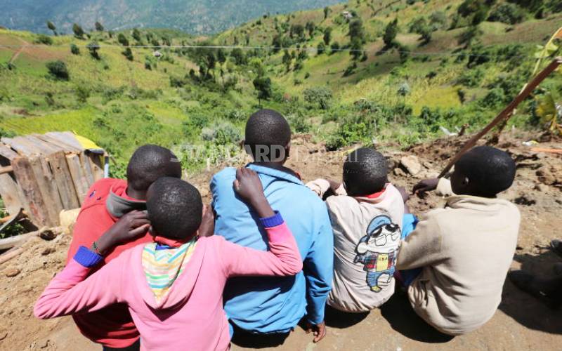
Children chat at a spot where a couple and their two children died last week after a landslide buried their house in Kapkonder village, Elgeyo Marakwet County. [Peter Ochieng', Standard]

It is mid-morning and Clement Lagat, a resident of Epke on the slopes of the Elgeyo escarpment, is outside his house basking.

He glances up as dark clouds start to gather, and a worried look crosses his face. It has been raining heavily in the last few days, and the area is prone to deadly landslides.

“We are disturbed by the ongoing rains because we suffered in 2012 when a landslide killed 16 people and left 1,500 homeless. We fear the rains might trigger another tragedy,” Mr Lagat tells The Standard.

He was among the residents who lost family members in that tragedy.

Still intact

“At night, there is a lot of rumbling in the ground as torrential floods sweep everything in their way. We are lucky that our homes are still intact. In some areas, the landslides have already swept away livestock and other property down the escarpment,” he says.

Another resident, Joseph Lagat, tells The Standard that he has already lost his herd of cattle to the raging waters and is afraid that worse is yet to happen.

“I woke up to an empty livestock shed. All my animals had been swept down the escarpment following heavy rains that lasted for over nine hours,” he says.

Last week, a couple and their two children were buried alive after a mudslide covered their house in Marakwet East sub-county.

Despite the breathtaking scenery offered by the Elgeyo escarpment, which stretches across the county, it has also proven to be a deathtrap for the residents who live on it.

Records from the County Disaster Department indicate that more than 50,000 families live on the escarpment.

Out of these, 4,000 have built-in high-risk zones that have fault lines, leading to perennial landslides.

Charcoal burning

Residents say the danger is largely a result of unbridled human activities, like charcoal burning and haphazard cultivation on the sides of the escarpment.

“There is widespread charcoal burning and little conservation efforts to mitigate environmental destruction. The region is steadily turning into a disaster zone,” Lagat says.

“From the floor of the valley, you can see smoke from numerous charcoal kilns across the landscape. Huge rocks have been exposed and they are now hanging precariously – a disaster waiting to happen.”

Residents blame the Government for snubbing their request for a land-exchange programme.

After the 2012 tragedy and 1997 El Niño rains, residents were prepared to move from areas declared dangerous for human habitation in exchange for land in more suitable areas.

Jelagat Komen says the Government had promised to relocate them, but this was yet to happen.

“We feel abandoned because after the tragedy struck, we were left impoverished. This region is said to be unsuitable for human habitation and we had agreed that it should revert to the Government,” she says.

Water, Environment and Natural Resources County Executive Abraham Barsosio says human activities on the escarpment were a major contributor to the perpetual landslides.

“There are settlements built haphazardly on the escarpment, farming activities and charcoal burning that interfere with the fragile environment and expose it to landslides each rainy season. Mapping is ongoing with the aim of removing those who have settled and cultivated in high-risk areas,” he says.

He adds that surveyors would erect beacons to guide residents on where building of houses and farming was outlawed.

“Unchecked human activities have resulted in killer landslides that have claimed lives and property. We want to avert such disasters in the future."

Water tower

Mr Barsosio says the escarpment, which stretches from Tugumoi in Keiyo South to Liter in Marakwet East, would have to be classified as a water tower to save it from further decimation, adding that residents had encroached beyond the ‘Spencer Line’, leading to wanton destruction of the fragile ecosystem.

The 'Spencer Line' was named after a colonial administrator, William Spencer, who demarcated a boundary on the escarpment beyond which no human activity was allowed. 

Barsosio says he wanted to restore the boundary and reverse the ecological harm that has also affected wildlife.

“As a county, we want the escarpment gazetted as a water tower to ensure it is conserved to prevent more catastrophe."

County Meteorological Services Director Simon Cheptot warns that more heavy rain could trigger landslides that could potentially displace thousands of residents.