All major rivers, dams and lakes full to ‘alarm’ levels, warns water authority

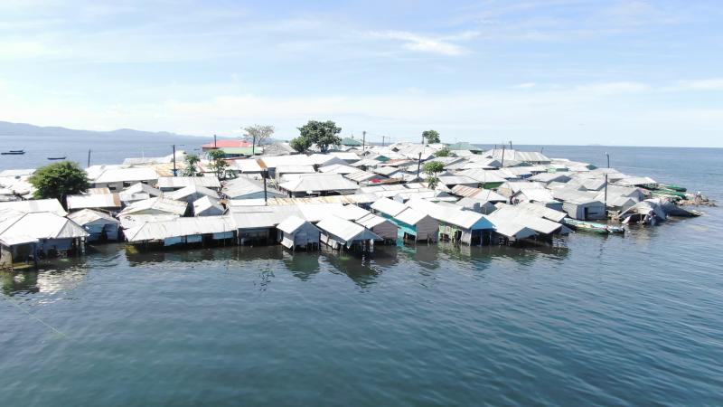
Remba Island in Homa Bay county has been affected by the increasing water levels in Lake Victoria. [James Omoro, Standard]

Water levels in rivers and dams across the country rose in the past one week to levels not witnessed in many years, says Water Resources Authority (WRA).

All the dams in the country are also beyond capacity, says the agency. This has been attributed to prolonged short rains in October, November and December last year.

WRA says most dams began spilling over during that period.

“Lake Victoria level has been rising from October 2019. It has so far risen by about 0.9 metres. As a result, the lake has reclaimed the riparian land, submerging settlements and farms within the contour buffer. This has caused increased backwater flow, leading to floods at the river mouths,” says a brief by WRA chief executive, Mohamed Moulid Shurie.

With the start of 2020 having been wet as opposed to the usual dry season in January, the long rains that began in the second week of March have only compounded the problem.

“Year 2020 started with a wet season, which is different from the conventional hydrological years where dry periods extend from January to March,” says the brief.

The long rains began in the second week of March, with heavy rains starting around mid-April.

The authority reports that since the soils were already saturated due to the prolonged 2019 October, November, and December short rains, the river levels immediately rose to flooding levels. The flows have continued to rise, overtopping the banks and are still very high in all rivers across the country.

The brief also says that human manipulation of watersheds, drainage basins and flood plains coupled with the effects of climate change have occasioned an increase in the magnitude and intensity of the floods.

“In some cases, floods have occurred in the river basins even with normal rains because of excess surface water runoff occasioned by deforestation and land degradation upstream,” reads the brief.

Most of the dams were already full and spilling at the onset of the long rains. The Seven-Forks dams on Tana River had been spilling since December 2019 and Ndakaini Dam is at full capacity, it noted.

Most of the floods have been at the Lake Victoria basin, the Tana catchment area and the Coastal strips. At the The Lake Victoria Basin, water levels in all rivers in Nzoia have risen above six metres, breaking the riverbanks and breaching dykes, which have caused the displacement of people at Budalang’i and Nyadorera.

Gucha Migori River, for instance, recorded the highest water levels in the last 10 years at 6.10 millimetres, thereby bursting its banks at Kadem in Migori County. Farms and houses were flooded, but no casualties were reported, with the surrounding community being on high alert.

In the Rift Valley, very high rainfall in the last one week has caused destruction and loss of life. According to the statement, the Narok-Maai Mahiu road at the Ngossur bridge near Eor Ekule Centre has been destroyed by floods and the road is currently temporarily closed.

An Administration Police camp, which is over 150 metres away from the banks, was submerged when River Suam at Kongelai burst its banks on the night of April 29.

Kiambu and Nairobi as well as lower parts of the basin around Kilifi are likely to receive moderate to heavy rainfall, while residents in the Tana Basin Area have been advised to move to higher grounds as the levels continue rising. There have been flash floods and three landslides recorded within the area.

The authority has begun putting in place mitigation measures to curb the situation, including Flood Early Warning System. Long-term measures include plans for the construction of dykes and mega canals and mega dams for flood control.