×

The Standard e-Paper
Home To Bold Columnists
 The Standard Group Plc is a
multi-media organization with investments in media platforms spanning newspaper
print operations, television, radio broadcasting, digital and online services. The
Standard Group is recognized as a leading multi-media house in Kenya with a key
influence in matters of national and international interest.
The Standard Group Plc is a
multi-media organization with investments in media platforms spanning newspaper
print operations, television, radio broadcasting, digital and online services. The
Standard Group is recognized as a leading multi-media house in Kenya with a key
influence in matters of national and international interest.

Audio By Vocalize
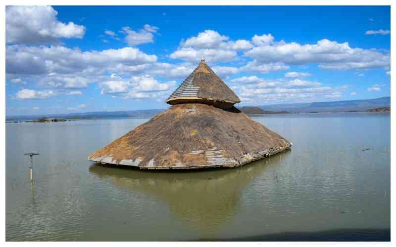
At 35 degrees on the shores of Lake Bogoria, the heat is unnerving.
Yet a team of experts drawn from different government departments is racing against time to deliberate on response mechanisms for when El Niño rains arrive.
Already, the Kenya Space Agency has completed and tabled scenario maps showing what is likely to happen if water levels continue to rise.
The Ministries of Education and Health are expected to table evacuation plans and outline next steps for health facilities and schools that have already been mapped as high risk.
The Ministry of Interior is also expected to have an evacuation plan for vulnerable families already living in risk zones.
Mapping has revealed that a mere two-meter rise in water levels would breach the narrow divide separating Lakes Baringo and Bogoria, a critical ecosystem that experts are now focusing on.
Such a merger would contaminate Lake Baringo’s freshwater ecosystem with Lake Bogoria's alkaline waters, devastating local fisheries, displacing thousands of shore-side residents, and irreversibly destroying critical flamingos and wildlife habitats that drive the region's tourism.
“Whatever is happening in Lakes Baringo and Bogoria is unique,” explains Dr. Pacifica Ogola, Director of the Climate Change Department and National Coordinator for Rising Lake Levels. “Although it is a dry season, water levels in the two lakes have been steadily rising. El Niño might accelerate this, and that is why we have singled these particular ecosystems as a concern.”
Beyond their ecological fragility, both water bodies hold distinct global and cultural significance, making a potential spillover even more devastating.
Lake Baringo is a critical freshwater haven supporting island communities and fishing and irrigation activities that feed thousands, while Lake Bogoria is a hypersaline UNESCO World Heritage site famous for its boiling geysers and massive flamingo flocks.
If Bogoria’s alkaline water spills into Baringo, the sudden change in water quality will kill freshwater fish like tilapia, destroying local livelihoods and drinking water sources, while the dilution of Bogoria’s alkaline waters would kill off the algae that sustains the flamingos.
The experts are racing to beat a 90-day deadline ahead of expected El Niño rains. To understand the changes within the two lakes, the team are reviewing satellite images from the last decade. They explain that regional rainfall has surged by 30 per cent since 2010, a trend that aligns with global climate models.
“This is not a surprise to us because the scientific models from the international community indicate that as the climate is changing, we will be receiving more rain in the Eastern Africa region and drought in Southern Africa,” Dr Ogola explains. “As we move into 2050 and the globe is warming, we are anticipating more rainfall, along with frequent El Niño and La Niña events.”
When catastrophic floods struck in 2020 and 2021, they submerged many institutions, including health facilities, schools, homes and farmlands.
Stay informed. Subscribe to our newsletter
The government's response was reactive, with teams conducting only post-disaster assessments to measure the destruction.
However, Dr Ogola stresses that the current approach is different.
“What is unique about this year is that we have decided to do the assessment and come up with an anticipatory action before the flood event happens,” she notes.
Part of what the teams are trying to prevent is worst-case scenarios. They are studying the landscape and exploring existing options to prevent the two lakes from merging.
Satellite mapping shows that Lake Bogoria, which sits on higher ground, is expanding northward, while Lake Baringo, currently sitting at a lower elevation, is stretching toward the south. This means that if water levels in Lake Bogoria rise by two meters, its saline waters will spill over into Lake Baringo.
Mapping experts and geologists are deploying high-resolution 3D simulation models to chart how the water will physically behave if the lakes breach their bounds. Their predictions show that the water from Lake Baringo is likely to spill through Loruk.
“When the water gets out of Loruk, it will find its own natural flow,” explains Hillary Kibiwott, spatial data and GIS analyst at the Kenya Space Agency.
Kibiwott says that the simulations give planners a clear picture before the rains start. “Through elevation mapping, we can identify exactly which road networks will be rendered impassable, where evacuation corridors must be established, and how vital areas like Marigat will be impacted.”
University of Nairobi spatial expert Fred Okeyo notes that historical data shows how rapidly the distance between the two lakes has shrunk over the last decade.
“Under normal conditions, Lake Baringo and Lake Bogoria were separated by over 21 kilometres. Through consecutive flooding cycles, that gap has narrowed drastically, in some stretches to just 7 to 12 kilometres apart,” Okeyo noted.
Okeyo warns that tectonic and geological factors compound the hydro-meteorological crisis. “These are geologically closed basins with no surface outlets,” Okeyo emphasises.
“As Lake Baringo’s depth increases, it causes flowback on major rivers like the Perkerra and Molo, pushing silt and water further inland into farmlands and residential zones. The ecosystem cannot self-regulate without intervention.”
Already, satellite saturation mapping has exposed another growing threat underground. It reveals that the aquifers are already waterlogged. Field teams who have been conducting the surveys reported that water is mysteriously seeping up, despite scorching surface temperatures.
“Because the earth has reached maximum saturation, its natural capacity to absorb additional rainfall is completely exhausted. When the El Niño rains arrive, nearly every drop of precipitation will immediately turn into surface runoff, directly threatening the region’s economic lifeline, including irrigation schemes near Marigat and surrounding farm plots,” Dr Ogola said.
The week-long discussions by the technical teams are considering different proposals, including constructing a relief canal system out of Lake Baringo to drop water levels down to a manageable level.
The Ministries of Education and Health are also expected to draw up sector-specific plans for schools and clinics at risk, especially given that the national examinations calendar is drawing near.
Environment Cabinet Secretary Dr Deborah Barasa stresses that this crisis is not an isolated local problem. She says that a symptom of a broader geological disturbance sweeping through the Great Rift Valley, from the saline lakes of Ethiopia and the Tanzanian Rift to lake basins across East Africa, which are expanding at unprecedented rates.
“The focus is on what we can do to salvage the families that are still living next to the lakes, the families that are in the risk zones based on their topography.”
Once they come up with solutions and what each miistry is supposed to do during an eventof worst case scenario, public participation meetings across mapped areas will be conducted. The multi-agency team aims to finalise and submit the integrated contingency plan for Cabinet approval before El nino begins.
Multi-agency mapping and ground surveys show that high-risk zones around Lake Baringo include Kiserian area. Villages including Kiserian, Ngasotok, Kiserian Center and Karong have been mapped. Schools including Kiserian Primary and Sokote Primary are projected to be affected by the floods. Although partially operational, the Kiserian-Sokote bridge is at risk. Kiserian-Nasuguro road is currently submerged. The rising water levels have also submerged Kiserian Beach Management fish landing, Kiserian market, and electric lines.
In Loboi area, the rising water levels in Lake Bogoria have submerged infrastructure including Loboi hospital, Koptellan ECDE, Loboi stadium, airstrip, and market as well as the Lake Bogoria National Reserve gate.
Roads that have been mapped as critical include Marigat-Bogoria Road at Loboi and the Kisbor-Bogoria bridge. Also lost are the cultural heritage sites, including Endorois cultural center and circumcision site.
Experts have also mapped the famous Ol Kokwa island as a hotspot. They have mapped Kiriapare Primary, Kokwe Boarding, and a bridge. It is projected that 641 learners on the island will be affected.
In the Nga’mbo area, 18 villages have been mapped as well as 98 households. 1,164 students across 5 schools are at high risk. Currently, Sitaan and Loropil primary schools are partially operational, while Ng’ambo primary and secondary schools have been relocated.
Subscribe to our newsletter and stay updated on the latest developments and special offers!


 Prefer the Standard on Google







 join
join