×

The Standard e-Paper
Fearless, Trusted News
 The Standard Group Plc is a
multi-media organization with investments in media platforms spanning newspaper
print operations, television, radio broadcasting, digital and online services. The
Standard Group is recognized as a leading multi-media house in Kenya with a key
influence in matters of national and international interest.
The Standard Group Plc is a
multi-media organization with investments in media platforms spanning newspaper
print operations, television, radio broadcasting, digital and online services. The
Standard Group is recognized as a leading multi-media house in Kenya with a key
influence in matters of national and international interest.

Audio By Vocalize
Narok Town and surrounding areas are on high alert as county authorities step up El Niño preparedness to avert flooding, displacement, and property destruction.
The town has been identified as one of Narok County's major flood-risk areas because of its natural basin-like landscape, which allows large volumes of surface water to drain into the urban area during heavy rainfall.
Narok County Director of Meteorological Services Stanley Kinyua said the county could receive above-normal rainfall during the October–December 2026 rainy season.
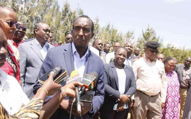
Kinyua was speaking at the third El Niño Preparedness and Response Multisectoral Coordination Committee meeting in Narok Town, attended by Governor Patrick Ole Ntutu, Narok County Commissioner Kipkech Lotiatia, and the Kenya Red Cross and disaster management teams, to strengthen preparations ahead of the expected rains.
“Narok West, Narok East, Narok North and areas around Kilgoris are among the areas expected to receive significant rainfall during the season,” said Kinyua.
The Kenya Meteorological Department has also warned that the rains could extend to January 2027, increasing the risk of flooding, flash floods and landslides in vulnerable areas.
For Narok Town, county authorities said the immediate concern is the large volume of water that flows from the Olopito area during heavy rainfall.
The town's terrain acts as a natural funnel, directing surface runoff towards local waterways and drainage systems.
The Enkare Narok River and Noosamburumburr stream can swell rapidly, threatening homes, businesses, roads and other infrastructure.
County authorities have particularly raised concern over two check dams in the Ntimama dam area, warning that the structures could pose a major danger if they become overwhelmed by excessive water.
They said previous flooding disasters have demonstrated the deadly consequences of overwhelmed water-control structures and drainage channels.
According to Narok County records, more than 20 people have lost their lives in previous flood incidents in the county, with some of the deadliest episodes recorded during periods of intense rainfall in 2014 and 2015.
The history of fatalities has heightened concern as the county prepares for another period of heavy rainfall.
“We need to be prepared for the currently expected El Niño rains that are feared to cause deaths, displacement and destruction of properties. We are aware that much water comes from the Olopito area and our disaster teams are in the area repairing the dams,” said Governor Ntutu.
Stay informed. Subscribe to our newsletter
“We are also reaching out to all residents of the county, and especially communities residing in high-risk areas like Narok Town, to heed the guidance of authorities, and not to wait, through inaction, and find themselves in harm's way,” he added.
Narok has a long history of destructive flooding, with previous incidents causing deaths, displacement and extensive damage to property and infrastructure.
The county's basin geography has historically contributed to rapid accumulation of stormwater in Narok Town, overwhelming drainage systems and local waterways.
Flooding has also disrupted major transport routes, including the Narok–Mai Mahiu Road, where heavy rainfall has previously caused erosion, silt accumulation, bridge damage, and temporary road closures.
“The meeting is to align our rapid response protocols and to ensure that we develop an actionable El Niño Preparedness Plan that will guide our response and mitigation efforts during the period,” Ntutu said.
He said his administration would work with private corporations, foundations, civil society organisations and faith-based institutions to strengthen disaster preparedness and response.
“My administration remains fully committed to collaborating with multi-sectoral partners including private corporations, foundations, civil society organisations, and faith-based institutions. Together, we will strengthen disaster risk governance, ensure uninterrupted access to clean water, sanitation, and health services, and reinforce nutritional security,” he said.
The county's preparedness programme covers agriculture and food security, livestock development, water resource management, health, education and disaster risk management.
Authorities have also established disaster-management operations and emergency response centres to coordinate interventions and monitor areas considered vulnerable to flooding and other weather-related emergencies.
County teams are expected to deploy machinery to clear blocked drainage systems, widen restricted waterways and remove structures obstructing natural water channels.
Beyond Narok Town, authorities have identified several other parts of the county that could experience flooding, flash floods and landslides during the rainy season.
Ewaso Ng'iro is vulnerable to flooding as rivers and drainage channels swell with water flowing from upstream catchment areas.
Mosiro is at risk of flash floods that could threaten pastoralist communities, livestock and homes. At the same time, Kilgoris faces the combined threat of flash floods and rainfall-triggered mudslides because of its terrain.
Nkareta, an important upper catchment area, is also vulnerable to rapid water accumulation and high-velocity runoff.
The Narok–Mai Mahiu Road is another major concern, particularly around Suswa and Karima, where heavy rainfall has previously caused severe soil erosion, deep gullies and damage to transport infrastructure.
The expected heavy rains are also likely to threaten tourism facilities within the Maasai Mara National Reserve and surrounding areas, particularly those along the Talek and Mara rivers.
County authorities have raised concern that rising river levels could affect hotels, lodges, camps, bridges, access roads and other tourism infrastructure, potentially disrupting operations and putting visitors and workers at risk.
Areas close to riverbanks are particularly vulnerable to flooding, as water levels rise rapidly after heavy rainfall upstream.
Governor Ntutu said sensitisation of hoteliers and other tourism operators is underway to ensure they are aware of the potential risks and take precautionary measures, including moving facilities and equipment away from riparian areas.
He said the county government was working with stakeholders in the tourism sector to strengthen preparedness, monitor river levels, and ensure early action is taken when flooding threatens lives, property, and critical infrastructure.
The Kenya Red Cross has also intensified preparations, with the organisation saying it has mapped communities considered vulnerable to flooding and other effects of the heavy rains.
Soila Sankale, the Kenya Red Cross county coordinator, said the organisation was ready to support the national and county governments in responding to emergencies.
“As an auxiliary to the national and county government, we are ready. We have mapped the high-risk areas and are already carrying out civic education to the public and are ready to support all that is geared towards alleviating human suffering,” Sankale said.
Officials say early warning, timely evacuation and coordinated emergency response will be critical in protecting lives and property as the rains intensify.





Subscribe to our newsletter and stay updated on the latest developments and special offers!








 join
join