Franco-US satellite set for unprecedented survey of Earth's water

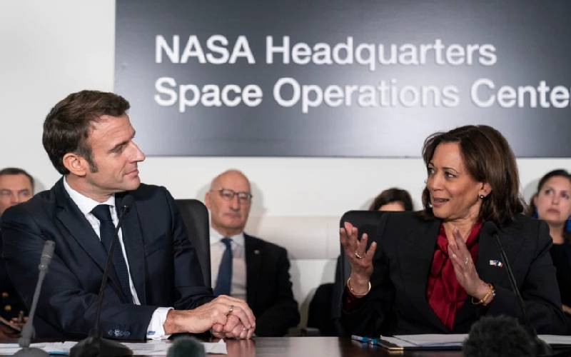
French President Emmanuel Macron, left, and Vice President Kamala Harris meet at NASA headquarters in Washington, Nov. 30, 2022. [VOA Photo]

A Franco-U.S. satellite is due for launch this week on a mission to survey with unprecedented accuracy nearly all water on Earth's surface for the first time and help scientists investigate its impact on Earth's climate.

For NASA and France's space agency CNES, which have worked together in the field for 30 years, it's a landmark scientific mission with a billion-dollar budget.

French President Emmanuel Macron went to NASA's Washington headquarters at the end of November alongside U.S. Vice President Kamala Harris.

He highlighted the liftoff - scheduled for early Thursday on the U.S. West Coast - of the Surface Water and Ocean Topography (SWOT) mission to monitor the levels of oceans, lakes and rivers, including in remote locations.

Its predecessor, TOPEX/Poseidon, launched in 1992, was also a Franco-U.S. joint venture that measured ocean surface to an accuracy of 4.2 centimeters (1.7 inches).

It aided the forecast of the 1997-1998 El Nino weather phenomenon and improved understanding of ocean circulation and its effect on global climate.

The 2.2-metric ton SWOT mission will be put into orbit from Vandenberg Space Force Base in California atop a SpaceX Falcon 9 rocket.

The satellite's primary payload is an innovative instrument to measure the height of water called KaRin, or Ka-band radar interferometer. Its two antennas, separated by a big boom, create parallel swaths of data.

"We're going to get 10 times better resolution than with current technologies to measure sea-surface height and understand the ocean fronts and eddies that help shape climate," said NASA Earth Science Division Director Karen St. Germain.

"It's like looking at a car number plate from space when before we could only see a street," added Thierry Lafon, SWOT project leader at the CNES.

The stakes are high. While the impact of major ocean currents such as the Gulf Stream is known, more local flows and eddies covering dozens of kilometers remain more of a mystery.

But they too affect sea water surface temperatures and heat transfer as well as the absorption by the oceans of carbon dioxide from the atmosphere.

SWOT will improve weather and climate modeling, the observation of coastal erosion and help track how fresh and saltwater bodies change over time.

With an "optimal" orbit of 890 kilometers (about 550 miles) above Earth, Lafon said SWOT will "take in all the components that affect water levels such as tides and the sun."

NASA said SWOT will survey nearly all water on Earth's surface for the first time.

It will monitor water levels, surface areas and quantities at more than 20 million lakes with shores of more than 250 meters. The entire length of rivers more than 100 meters wide will also be observed.

Water management, flood and drought prevention will be improved, said Lafon.

Flying the satellite to Vandenberg from the Thales Alenia Space (TAS) site in Cannes, southern France, proved a headache.

"Due to the conflict in Ukraine, there were no more Antonov 124s available, and the 747 cargo is too small," said TAS project leader Christophe Duplay. "We decided to ask the [U.S. Air Force] to provide one of its C-5 Galaxies."

And that meant counting on NASA to have the air force supply one of its rare giant aircraft to ship the huge payload.

SWOT has an estimated three-year lifetime - although Lafon said "nothing precludes the mission to last five to eight years" - and is set to become the first satellite to make a controlled reentry into Earth's atmosphere, reducing the amount of space debris, in line with the French space operations act.

Nearly 80% of the 400 kilos (880 pounds) of onboard fuel will be used to that end.