Nairobi traffic and possible solutions

Traffic jam along Thika Super Highway near Ngara. [Elvis Ogina.Standard]

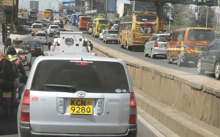
The National and Nairobi County governments have been carrying out a trial and error exercise aimed at either decongesting the City or attaining free traffic flow without major success. Notable among the trials are closing off some roundabouts, abolishing right turns at minor junctions, installation of new street lights (at the moment each roundabout has at least 3 sets of street lights installed by different regimes – most probably without a synchronised traffic lights system), introduction of terminus outside the city centre and lately car-free days.

Little has been felt in terms of time spent in traffic, especially in the evening and morning hours . It is important to appreciate the Government’s effort to push as much traffic out of the city centre as possible by construction of a road through Kibera slums connecting Ngong Road and southern bypass, dual road connecting Waiyaki Way and Limuru Road, connecting Hospital Road in Upperhill and Mbagathi.

Tall order

A city of Nairobi’s size requires a broader master plan, not the piecemeal trial and error measures being carried out. In addition to that, a working rail transport, free follow of traffic through the city without interference with city centre’s activities and creation of parking areas around the city would come in handy. How to achieve this is what I think has been a tall order for successive governments and different city leadership regimes. To understand how minor items affect city traffic, I make reference to Lunga Lunga Road in Industrial area which was heavily potholed. The road has been re-carpeted and because of that, traffic time between Likoni Road-Enterprise Road junction and Lunga Lunga Road-Mogadishu Road junction has reduced from 30-45 minutes to a mere 10-20 minutes.

If the Government was to move ahead with re-carpeting of Likoni Road all the way to Jogoo Road, the 10-20 minutes would definitely reduce as there is still some traffic snarl-up due to huge potholes. Another example is the speed bumps along Thika Road. The amount of traffic jams they cause need no explanation. However, it would be important to note that the national government is working on the same although at a slow pace. Another element to figure out is the effect of practicing professionals and consultants in the city centre and the number of driving employees and clients they pull into the city centre, a good example is when the court/judiciary is in recess; traffic within the city centre eases or declines.

What to do?

As a result, the Government may wish to re-carpet all major roads within and outside the city, attain free traffic flow along Uhuru highway, Haile Selassie Avenue, Ring road, Muranga road, Prof Wangari Maathai Road and University Way, set up of parking lots and matatu terminus along mentioned roads, identify areas of heavy human traffic and the possibility of rail transport use in those areas e.g. industrial area, evaluate possibility of opening up of the two roads between Nairobi river and Kirinyaga Road, which are currently not easily accessible as they have been converted into garages and finally, movement of matatu terminus from Tom Mboya street and old nation roundabout.

The question that arises is how to achieve above items. There exists theoretical solutions which may be enhanced through research and expert input. The possibilities are; by attaining free traffic flow along the identified roads, the government would ensure that a vehicle can move around the city without affecting the city centre or traffic from major roads into the city.

To attain this, it would be important to address the following junctions or roundabouts; University way-Uhuru highway, Kenyatta avenue-Uhuru highway, Haile Selassie avenue-Uhuru highway, Moi avenue-Haile Selassie avenue, Haile Selassie avenue-Ring Road-ladhies road-jogoo road. The free traffic flow created along the identified roads would be the official route for BRT. Further, it is along those roads that the government would set up terminus and parking lots. The new parking lots created would charge parking fees at 10 per cent of the city centre charge, say, Sh20 against Sh200 in the city centre.

Note that all major roads into the city access the city centre through the identified roads. The government can acquire or enter into an arrangement with Kenya Railways to set up multi storey parking lots on the section along Haile Selassie avenue, Uhuru highway and Bunyala Road. Note that there is heavy human traffic into and out of industrial area, majorly through the city centre, to residential areas around the city and Eastlands.

Other roads

There exists a rail system in industrial area which was in use for delivery of goods to manufacturers. How about re-activating the rail for passenger trains into and out of the city before working on other areas by opening the two roads between Kirinyaga Road and Nairobi river, which are now in use as garages? This would enable the government to convert a number of roads into one-ways streets. Setting up terminus along the identified roads would ensure that PSV’s do not get into the city, freeing a lot of road space that is now occupied by PSVs resulting in traffic congestion.

Using Thika road into Muranga Road or Ring Road you will note that there is a major bottleneck at globe roundabout and old nation roundabout caused by matatu terminus’ along Tom Mboya street and River road. Other roads whose traffic is greatly affected by matatu terminus are Racecourse Road, Ladhies road, Ronald Ngala Road, Luthuli avenue, Latema Road.

By also setting up parking lots along the same routes that are cheaper than city centre would ensure that private users utilize them and use BRT to access the city, in most cases private cars users park in the city centre and conduct all their other business either on foot or by use of taxis and matatus.

Mr Tito is a resident of Nairobi