A 24km buffer zone is at the heart of Mau forest eviction crisis

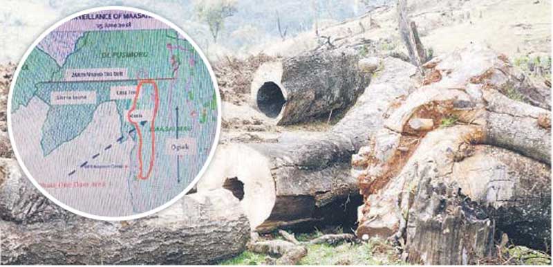
Some indigenous tree cut down at Maasai Mau in Narok County on July 21, 2018. Inset: A map showing the cutline where families are being evicted. [Kipsang Joseph, Standard]

Nicholas Kimetto has maintained that he rightfully owns 43.98 hectares in the Mau Complex.

Mr Kimetto, from Narok South, said the Registrar of Lands in the then Narok District issued him a title to the land in 2004 and he did not, therefore, understand why he has been evicted.

He said he thought the title deed would save him when the Government announced it would evict those who had encroached on the forest.

Kimetto’s sin, as he came to learn, is that his land is part of what the Government is calling the cutline. The cutline refers to a 24-kilometre buffer zone between the forest and human settlement.

The cutline was established in 2008 on the recommendation of a task force set up to look into ways of saving the Mau Complex.

Among thousands 

Kimetto is among thousands of settlers the Government has accused of encroaching on the buffer zone, which separates Maasai Mau and Olpusimoru Forest Reserve.

Most of those affected by the evictions argue they are not in the forest. However, they were found to be within the cutline. 

And despite the heat the evictions are generating, the Government has maintained it will leave no structure standing on the cutline as it strives to restore the water tower. 

Narok County Commissioner George Natembeya has accused leaders of politicising Government efforts to conserve the Mau and asked them to instead support the exercise.

“It doesn’t mean those who are not near the demarcation line but are still in the forest haven’t encroached. We are removing all settlers from the forest,” Mr Natembeya said.

He said verification of title deeds for land in Sierra Leone will establish the number of people the Government will either compensate or resettle.

Some politicians have waded into the debate, claiming some of the settlers had unfairly been targeted by the ‘inhumane evictions’. They want the Government to stop the exercise.

However, there are those supporting the Government, saying reclamation of the water tower is a matter of national importance and does not target any community.

At the weekend, some South Rift leaders turned the heat on Environment Cabinet Secretary Keriako Tobiko for sanctioning ‘biased’ evictions.

They also accused Mr Tobiko of misleading President Uhuru Kenyatta over the cutline.

Kipkelion West MP Hillary Koskei argued that although a buffer zone of tea bushes had been planted around the forest, the evictions have been designed to overshoot the mark.

This came even as a section of Maasai leaders issued a two-week ultimatum for the Government to evict the remaining 40,000 settlers at Caveat.

Speaking at Nkareta trading centre in Narok North on Saturday, leaders including Senator Ledama ole Kina, Narok North MP Moitalel ole Kenta, former Nairobi county assembly speaker Alex ole Magelo, blamed the Mau woes on a group of ranches that they claimed had been illegally expanded, thereby eating into the protected areas.

So, what is causing the controversy if the cutline is as clear as Natembeya has explained?

Various reports on conservation initiatives say that had it not been for the extension of boundaries of five group ranches that border Maasai Mau, there would have been no settlement inside the forest.

A May 2017 United Nations Environmental Programme (Unep) report estimates that because of years of destruction, the Mau Forest tree cover is at a critical 1.7 per cent.

Between 1973 and 1986, the report says, 14,278 hectares of Maasai Mau were destroyed.

The entire 427,000 hectare Mau Complex was gazetted as a forest reserve in 1954.

Illegal extension of group ranches in 1997 created 1,962 parcels of land amounting to about 14,103.7 hectares.

Massive encroachment

The extension, which encouraged massive encroachment, now stands at about 20,000 hectares after further changes were made in 1997 to accommodate more people.

Sisian, Enainkishomi, Reiyo, Enoosogon and Enkaroni ranches had boundaries stretched about 10 times.

Sisian’s boundary was extended from 447.5 hectares to 1,215 hectares and sub-divided into 383 sub-plots.

Among the sub-plots was Narok/Cismara section 374, whose area was 6.28 hectares. It was divided into 45 parcels.