Kajiado's population pressure prompts plan rethink


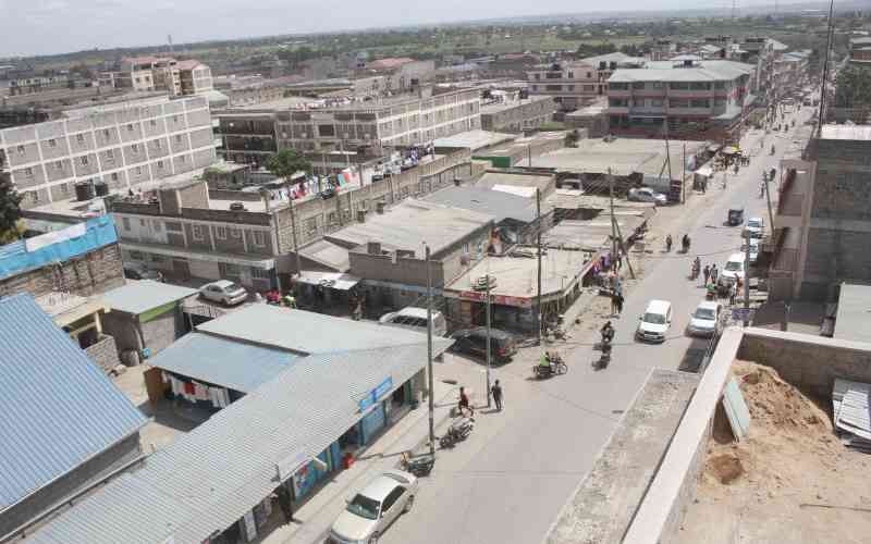
An earial view of Kitengela town in Kajiado county. The highly populated town has allegedly turned to be a criminal haven. [Peterson Githaiga, Standard]

Kajiado County is banking on a new spatial plan to address encroachment and excessive subdivision of land which has been linked to population pressure.

The plan also details how encroachment is eating up arable land and invading wildlife conservation areas. Nairobi National Park is adjacent to Kajiado County.

The plan contains strategies on how to handle some of the challenges the county faces as a result of unplanned developments such as traffic menace, roadside trading, scattered rural settlements and low economic activities in some markets.

The County Spatial Plan (CSP) 2020-2030 notes that 16 per cent which is equivalent to 3,468.4 km squared, of the total county land is arable. It notes that the average land holding size is 9 hectares on a small scale and 70 hectares in rural areas.

The document notes that due to the dynamics affecting land use in Kajiado such as an increase in population that exerts pressure on land use, there are proposals for sustainable lots sizes for both rural and urban areas.

“The increased subdivision of land in the urban areas and their surrounding has resulted in reduced land for grazing and wildlife conservation,” the plan states. “Further, the increased demand for land has also resulted in the encroachment into environmentally sensitive areas such forests.”

According to the plan, Kajiado County being located within the Nairobi Metropolitan Area experiences one of the highest rates of urbanisation which stands at seven per cent according to Nairobi Metro 2030.

Numerous centres

The developments, the plan states, have taken a dispersed arrangement resulting in numerous centres across the county. Urban areas are being influenced by the development of roads. This is the case with satellite towns of Kitengela, Ongata Rongai and Ngong. Other areas are: Kiserian, Isinya, and Oloitoktok.

Some of these urban developments, namely Ngong’ Ongata Rongai, Kajiado, Isinya, Kitengela and Kiserian, the plan states, have a sprawl effect which then informs the need for proper urban management. This sprawl effect has been witnessed in the last three years in Ngong’ Ongata Rongai and Kiserian where the plan notes there has been tremendous expansion.

“The increasing urbanisation has led to the fragmentation of land and highly appreciating land values for residential use,” the plan states. “The increased subdivision has resulted in encroachment into agricultural land leading to the decline of agricultural productivity and diminishing grazing areas.”

The plan also reveals that this rapid encroachment has seen settlements in riparian zones and natural forests.

This rapid urbanisation, the plan unveiled on July 23, cites increased urban growth and developments associated with the Nairobi Metropolitan Area. This is because of increased population growth, availability of land for urban development and accessibility linkage areas to neighbouring counties.

“The expanding urban areas necessitate proper planning to ensure managed developments,” the plan states.

The plan details submissions from stakeholder consultations at the sub-county level which categorise major issues of physical planning per category as urban sprawl, urban expansion into agricultural land, uncontrolled urban development, insufficient physical and social infrastructure and environmental degradation.

“These problems are caused by the demand for urban services in the context of non-existent urban development plans, lack of comprehensive development management system, and insufficient capacity for urban development management,” the plan states.

Under those categories of physical planning issues, the county spatial plan lists double allocation of plots, undefined urban boundaries, land grabbing, and uncontrolled land subdivisions, among the challenges.

Informal settlements

There are also cases of mushrooming of informal settlements, conflicts between Kajiado and Taita Taveta counties, and unidentified areas for grazing and farming as witnessed in Kajiado South.  

According to the plan, the county also faces the challenge of unregistered land. This is particularly true in rural areas.

It notes that other than in the areas having group ranches, most of the rural areas have had land parcelled and have either title deeds or letters of allotment.

“For the land parcel where homesteads are located, the most common land tenure ownership is with title or allotment at 65 per cent,” the plan states.

The county did identify scattered rural settlements as one of the issues that need to be addressed in the plan.  The county notes that rural areas have the most population at 76.53 per cent with the remaining being in the urban centres.

The settlement patterns, the plan states, are influenced by the availability of natural resources, soil fertility, rainfall pasture, infrastructure, economic opportunities and proximity to Nairobi City County.

“Scattered human settlements are very expensive to provide with infrastructure and social amenities compared to high-density settlements such as urban centres,” the plan says. “Future County Spatial Planning should encourage settlements in compact well planned serviced towns and market centres.”

Traffic menace

 The plan has in place strategy as well to deal with traffic menace which affects the urban centres that though less populated when compared to rural, are congested.

“Town planning and traffic management sections should provide adequate parking lots in towns,” the plan states. “Every urban centre should have designated packing for public transport vehicles and lorries.”

Adequate parking for private and business vehicles should also be provided in the spatial planning.

“Strict traffic management strategies should be employed,” it adds.