Kenya's Journey in the Development of Nano Satellites

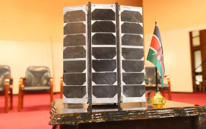
Prototype of Taifa-1 that was to be launched in America as planned on April 13,2023 in United States. However, weather condition did not allow the project did not continue as planned. [Denish Ochieng, Standard]

Commercial operators have developed a satellite for effective, reliable and inexpensive services and solutions in broadband communications, earth observation and remote sensing.

Kenya's entry in space systems engineering capability began in 2017 with the development of the first Kenyan Nano satellite, the first Kenyan University NanoSatellite - Precursor Flight.

This was a technology demonstrator and capacity building project for Kenyan engineers in space systems engineering.

The satellites have become attractive owing to their relatively simple, fast design and development requirements as well as cost-effective designs.

The Kenya Space Agency is leveraging these to develop national capability in space systems engineering and operations.

Deliberate capacity building efforts realized through beneficial collaborations with local and international partners has developed Taifa-1 Satellite.

Taifa-1 is an optical satellite with two imagers for its primary and secondary missions designed to deliver panchromatic and multispectral imageries respectively.

The project entailed research and development of the different components of satellite mission design, full satellite development cycle, in-orbit control, and data reception and processing.

The satellite is the first of what is intended to be a constellation of small earth observation satellites, with subsequent systems expected to be of higher capability.

The satellite aims at realizing capacity building on space systems engineering, space operations, data processing and analytics, as well as ground receiver station services and operations.

In addition, it will achieve Technology demonstrator on what capabilities or flexibilities we can realize with our own / sovereign earth observation asset.

It will also spur interest in investing in the development and deploying of more capable systems as well as catalyse the growth of Kenya's startups in the space sector.

The multispectral imageries will be useful for decision support in environmental monitoring, climate change monitoring and mitigation, food security through crop condition monitoring and crop yield estimation, disaster management, and natural resources management, among others.

The Taifa-1 satellite comprises four primary sections: the payload, satellite bus, ground segment, and image processing segment.

The payload of the Taifa-1 satellite is a multispectral imager for imaging. This is considered the most important section of the satellite because it determines the success of the mission.

The satellite bus is responsible for providing service-related functions to the satellite, including providing power, thermal control, and communication capabilities for the satellite.

The control ground segment manages, controls, and operates the Taifa-1 satellite and any other satellite when granted access.

It is responsible for receiving data monitoring the satellite's health and status, sending commands to the satellite, and receiving data from the satellite.

The control ground segment plays a critical role in ensuring that the satellite operates correctly in space.

The image processing segment performs data processing, handling, and archiving.

It is responsible for transforming the raw data captured by the satellite into useful information that can be used by decision-makers in various fields.

The medium resolution multispectral imager will provide valuable information about the composition and condition of the Earth's surface.

The high resolution panchromatic band will be used for pan sharpening, which entails using a higher-resolution panchromatic image to fuse with a lower-resolution multiband satellite image to produce a much higher multi-band satellite image for the six spectral bands.

The data and images captured by the cameras will be stored on-board the satellite and transmitted to the ground station for processing and analysis.

The insights and information gathered from the analysis of this data will provide useful information to policy and decision-makers in the diverse various fields of applications seeking to address the multiple challenges facing the country.

The satellite was successfully deployed into orbit on May 11, 2018. Since then, KSA engineers in collaboration with University of Nairobi, Jomo Kenyatta University of Science and Technology, Kenyatta University and Technical University of Kenya continued with capacity building efforts towards development of a larger 3U satellite engineering model.

These gained skills have yielded the development of Taifa-1 Satellite which has been motivated by socioeconomic development imperatives.

Hillary Kipkosgey said the launch will enhance flexibility and ability to acquire imagery at will, at the desired resolution and repetition rate, and responsiveness to time-critical requirements.

''The development of Taifa-1 earth observation satellite is part of continuing effort to develop national space capability and enhancement of utilization of space services for socioeconomic development,'' Kipkosgey said.