Satellite images aiding pastoralists to identify pasture

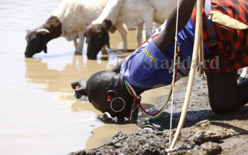
A herder quenching his thirst alongside his Livestock at Lokiwach water pan in Silale, Baringo. [Kipsang Joseph, Standard]

Northern Kenya is home to pastoralist communities as well as wildlife conservancies. The vast rangelands are arid or semi-arid. With the changing climatic conditions, including unpredictable rainfall patterns, competition for pasture has increased considerably. Water scarcity is also a source of great concern.

Lack of current and reliable information on the conditions of pasture and water availability has thus been a challenge to the pastoral communities and the conservancies. Although their desire would be to have information that would help them predict these conditions in a timely manner, the availability, accessibility and capacity to process it magnifies these challenges.

The northern rangelands are also infested with invasive species such as Opuntia Stricta, Acacia Reficiens and Prosopis Juliflora (Mathenge) which are not good for animals. Their evergreen characteristic, even during dry seasons, also gives false pasture conditions when derived satellite vegetation indices are used. It is therefore important to know the location and spread of the invasive plant species to avoid using misleading information.

To address these challenges, the pastoralist communities in Laikipia, Marsabit, Turkana, Wajir and Garissa counties have been working with Mercy Corps and Regional Centre For Mapping Of Resources For Development (RCMRD) to conduct participatory mapping of grazing zones. Using their paper hand-made maps, they are assisted to use satellite https://cdn.standardmedia.co.ke/images to develop better and more accurate maps and trained on how to use them so that they can better manage the grazing areas.

This effort is aimed at equipping the communities with information on availability and condition of pasture so that they can make more informed decisions when moving their cattle from one region to another in search of pasture and water. These maps are also an important input in the county government ward planning processes and assist in identification of priorities for investments.

The National Drought and Management Authority has been actively engaged in identifying innovations for strengthening their drought and early warning systems to improve responses to droughts. In collaboration with University of Sussex and RCMRD through the SERVIR Eastern and Southern Africa project, development of a web-based Rangelands Decision Support Tool that includes vegetation conditions as well as short-term vegetation forecasts provides the much-needed information to enable more accurate and timely decisions.

The forecasts are based on satellite-based vegetation data provided on a monthly basis. The web-based tool facilitates near real-time assessment and monitoring of rangeland resources and aggregates key indicators of rangelands productivity with ancillary data. The users are able to select those indicators to produce maps at different administrative and conservancy boundaries.

The collection of this data is done via a mobile app that enables local conservancy officers to map the occurrence of the invasive plants as they carry out their other daily operations within the conservancies.

Ms Wahome is the Science and Data Lead, RCMRD 

Enterprise
Premium Consumer spending shoots up on higher prices
Business
CS Miano flags off first locally assembled electric buses
Business
No reprieve for bank in Sh33 billion case with Manchester Outfitters
Opinion
Premium Sugar cane farmers should now move to dairy, avocado farming