Aberdares is graveyard of plane technology

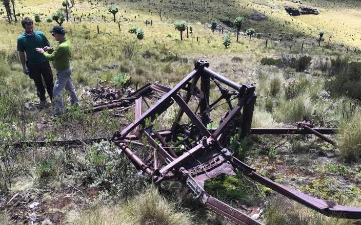
Wreckage of a WW II Blenheim bomber in the Aberdares. John Romain is on the right. Photo by XN Iraki. [File, Standard]

Long before the Ethiopian plane crash, another crash had mystified us for 77 years. It happened much earlier in 1942 during WW2. The wreckage lies in the moorlands of the Aberdares about 12,000 feet above sea level near the source of Malewa River, the key inlet to Lake Naivasha. And not far from Satima Peak.

Tom Lawrence, an amateur historian, suggests that the plane had flown from the airforce base in Nanyuki. The nature of this training flight as yet is unknown. It had a crew of three South Africans on board and crashed on July 4, 1942. The plane wreckage was found on January 9, 1943 by Morgan-Grenville who lived in the Happy Valley. The crew were deemed as ‘Missing in Action’ and despite the plane being found, the bodies were never recovered.

Lawrence added that for the Commonwealth War Graves Commission to potentially re-memorialise the casualties of any ‘Missing in Action’ aircrew, a 100 per cent identification of the aircraft is the first step of three major steps. The subsequent steps are to get the ‘home nation’ to give their permission (in this case South Africa). If they do agree, the next phase is to get agreement from all of the next of kin.

On January 18, 2019 we made a second visit to try and investigate what brought down the Blenheim bomber, one of key planes that turned the tide of WW2 in favour of the British. We also wanted to positively identify the plane. To make our life easier, we brought in John Romain, a Blenheim expert who flies the only such active plane in the world. He is based in Duxford UK where he rans Aircraft Restoration Company with his son George. John had helped identify a similar aircraft found on Mt Kenya in 2002, which disappeared on a training flight on July 23, 1942.

Other enthusiasts in our group included a recently graduated high school student, flower farmers and a relative of a veteran of WW2. We decided to camp and give ourselves more time. Camping at 12,000 ft above sea level was fun but subzero temperatures made it a test of endurance.

We spent the first afternoon analysing the wreckage scattered on a slope overlooking the source of Malewa river. Romain and his son could recognise every piece of the wreckage by name. He told us that their current Blenheim was retrieved from the Canadian prairies and restored to flying conditions. They restore such old planes to flying enthusiasts from all over the world that include German planes that squared off against Blenheims in the war. After the cold starry night, we continued the next day analysing piece by piece, including their GPS location.

Our biggest mission was to try find out what brought down this plane on July 2, 1942. During our previous visit in 2016, we found some shirt buttons, a clear indicator that the plane had some crew on board. Records show the plane had a crew of three and was on a training mission; this was during a war. Some locals say they found some skulls of three adults many years ago. That has not been confirmed. Did Grenville see them?

A photo taken six months after the crash shows the wreckage on a flat piece of land, not a slope. Maybe that was our mistake, focusing too much on where the main fuselage lay with the wings, with much of the metal sheets gone. The engines were about 300 metres from the main fuselage and wings. The landing gear was about 50 metres from the cockpit and wings. How did the engines go so far away?

Romain figured out that the plane was facing south when it crashed. That is why the engines kept rolling almost to the river. He argued that we needed to check farther north along a straight line. Up the hill was the flat ground we had ignored and the possible site of the photo.

This was a section we had never explored. We all walked in a straight line to cover as much area as possible. Within minutes some pieces of the wreckage started showing up. One big piece of metal half buried caught our attention. Romain said it was a piece of the propeller system driven by the engine, its gears intact. 

It was about 300 metres from the main fuselage. This seemed to suggest that the plane hit the ground around the flat ground, and the propeller and its mechanism got stuck on the ground. The impact must have sent the fuselage and engine and other parts forward into the slope.

Fly around

Finally, we could explain how the plane went down but not why. It was flying from north to south, from Shamata-Nyahururu side towards Satima peak. Where was it going?

Being a training mission, it was possible to fly around and explore or get lost. But not to the mountains. How then did the plane end up there?

The date, July 4, 1942 might offer the clue. This is usually the rainy reason around the Aberdares. It used to be very misty with poor visibility before global warming took over. Could the weather have played a role in bringing down the Blenheim bomber over the Aberdares?

Without an investigator’s report, we may never know what brought down this plane. It is possible that in war, we can push the limits including training in bad weather.

Seventy-seven years is a long time and lots of details and memories have vanished into the mists of history. If our research on this plane started about two decades ago, we might have met some eye witness who could have heard or seen the plane before its crash. The site, on the northern edge of the Aberdares, is visible from lots of farms owned by former British and Afrikaans settlers. That includes General Reginald Arthur Waineright who farmed about 15km from the site. Nigel Trent’s farm hugged the Aberdares; De Wet, Johannes Eduardo Crous were all nearby.

The Aberdare ranges, despite its beauty, is a graveyard of planes. They hide among the thick forests, ravines and moorland. That includes one belonging to Sax Fly40 that crashed last year and a Lockheed in 1959.

We may never know what brought down the Blenheim in 1942. We still did not get the unique plate that identifies the plane. That might require another trip up the mountain. The plane will remain part of Kenya’s history and our contribution to help the British empire win WW2.

Did I hear that there were harambees in Kenya during WW2 to help buy planes for British war efforts? The planes were named after contributors; for example, Meru, Kamba... Anyone who can remember or contributed?

From Blenheim to Boeing 737 MAX, technology has advanced but has limits. That should not stop us stretching the limits particularly for peaceful use. And when is Kenya making its first plane? Are other nations not so far ahead exploring the outer fringes of the universe? How can we immortalise this wreckage for our progeny to see where we came from technologically?

- The writer teaches at the University of Nairobi.