Vihiga taps into satellite-based technology to map location data

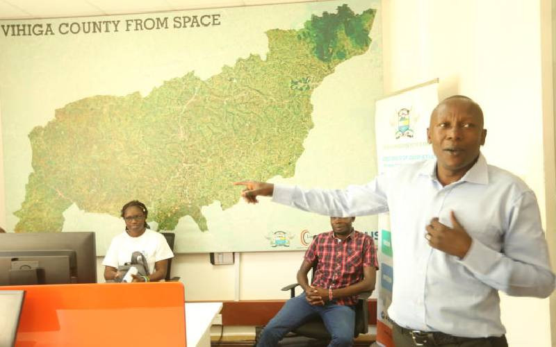
Vihiga county geospatial technologies services lab Director Washington Olando explains how the geospatial technology services works at the laboratory at county headquarters in Mbale on January 4, 2023. [Benjamin Sakwa, Standard]

It is arguably one of the smallest devolved units but Vihiga is fast becoming a model county in Kenya.

At least 23 counties, government agencies, and private firms have visited Vihiga on a learning or benchmarking mission in the last four years.

Most of them are impressed with the huge strides made by the county following the deployment of space technologies and geographic information systems (GIS) to facilitate planning and management.

Kisumu Governor Anyang' Nyong'o led his cabinet and top county officials in visiting Vihiga recently on a learning mission.

"I am impressed by everything, I wish I came much earlier because this technology could have easily won me the election without having to run around campaigning. It can help you figure out where the bulk of votes is," said Prof Nyong'o amid laughter.

It is a partnership initiative involving three companies, namely France-based Airbus Defence & Space, US-based Esri and Kenya-based LocateIT that selected Vihiga as a model county for the project in 2018.

Vihiga is a champion county in embracing spatial technologies in the management of the county administration affairs as envisaged by the County Governments Act 2012 which requires the devolved units to adopt the technologies.

GIS uses location-based data collected via satellites, paper maps, and directly from the field through mobile positioning devices to map out resources for analysis and decision-making.

Vihiga governor Wilber Ottichilo, a space technology, and GIS expert is excited about his achievements.

Ottichilo says the technology has helped the county government in supporting prudent management and allocation of resources while also facilitating rational decision-making processes.

By use of geographic information, the county government is able to make informed decisions when it comes to planning and distributing projects equitably according to the county chief.

Washington Olando, the Geospatial Technologies Services (GTS) director at Vihiga county said the system enables any government to make key decisions that enable development in all areas without discrimination.

The Geospatial Technologies Services laboratory has data for all projects done by the county and also helps in monitoring projects being implemented.

Mr Olando explains that before GIS was introduced, Vihiga County experienced challenges in terms of planning and distributing projects across wards owing to the absence of a County-Level Formula (CLF) to distribute resources.

"The first regime had a lot of troubles on how to objectively determine gaps in each sector without appearing to favour a particular area," said Olando.

The official confides that the past skewed developmental agenda necessitated the need for a technology that would address the challenge once and for all.

GIS technology was fully operationalised in Vihiga in 2019 and links five sub-counties of Vihiga, Sabatia, Hamisi, Luanda, and Emuhaya to streamline services across the 25 wards.

The technology provides the GIS with images frequently to help closely monitor ongoing development projects in the county.

"The satellite technology enables us to monitor our programmes and thus ensure their implementation," said Olando.

"It is one way of automating services with the aim of improving efficiency as well as sealing loopholes through which public funds are lost," said Olando.

The technology can identify areas in dire need of road connection or department that requires urgent support in terms of funding among other things.

It is also used to enhance various social amenities such as schools, hospitals, dispensaries and markets.

"In agriculture, we are able to know where to give subsidised farm inputs like fertiliser or seeds, there is no more random distribution of the farm inputs like was the case in the past," said Olando.

The system has also helped streamline the budgeting process and give evidence-based development needs to the people, thereby attracting support from development partners according to the official.

Dr Ottichilo said GIS has helped him to manage resources efficiently and effectively for the benefit of the residents including forest areas, water, minerals, wildlife, and wetlands through developed spatial plans.

According to him, the technology was key to his re-election in 2022 as the county's governor "because it helped me take my development agenda to the electorates."

"GIS offered a clear look into issues affecting the residents and came in handy in implementing policy framework and enhanced feedback. "Most people may not know but GIS and its utilisation and implementation was key to my second victory," said Ottichilo.