Physical planning the only way to live with floods peacefully

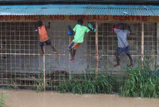
Children struggle to make their way along a flooded road at Mtwapa in Kilifi County. [Kelvin Karani]

Floods have displaced communities and killed scores of people besides causing loss of lives and property despite  warnings from the meteorological department.

Urban areas have been vulnerable to flooding not because of rainfall but due to lack of urban planning and limitations in related policies and plans to make urban areas and cities resilient enough to absorb the shocks.

These result from an inadequacy of manpower, finances, and political good will among many other factors. Flooding is not ending but approaching the beginning of worse situations which communities must be prepared to face irrespective of weather forecasts or reactive measures.

Over the years, rapid population growth and land use transformations have systematically destroyed traditional drainage systems and waterbodies with unplanned, mindless urban expansion disregarding the future and sustainable development.

Illegal property developments cause floods, encroaching on and filling up natural drainage channels and urban lakes.

The recent flooding would have been avoided with proper urban planning. Piecemeal development commonly witnessed in urban sprawls triggers floods because it is difficult to develop comprehensive drainage system in the context of isolated and scattered developments.

To avoid this scenario, physical planning should come earlier than development. Infrastructure, including storm water drains, should precede development in ideal situations but in reality, infrastructure follows physical developments.

The trend is similar in rural areas where population pressure leads to over-cultivation and deforestation. We must, therefore, map out ecologically-vulnerable spots and comprehensively survey waterbodies and waterways and plan mitigation measures.

Authorities must revise policies and confront illegal developments in areas that were once wetlands, riparian reserves and waterways.

Storm water drainage from neighbourhoods must be managed and directed to a central drainage system and preferably a low-lying area which can be treated and used for other activities.

Every place must have a disaster management centre with risk reduction strategies and vulnerability analysis which we do not seem to have any intention to have.

After catastrophic floods the predictable questions are whether we have had any disaster-related database on human and property loss for the past 50 years. Whether we know how long it takes for an individual to recover from disaster. Whether we have sound resilience plans in place to help withstand climate-related natural disasters.

 It is also asked whether we know the scope of developments occurring near waterways, riparian reserves and other ecologically-fragile zones.

 Wondering is also done about what has happened to urban sponges or the urban green spaces that soak up water which have now been replaced with a concrete jungle and  whether proper urban planning have prevented such a disaster.


Way forward

A multi-dimensional approach must be employed to solve the perennial problem with the help of urban planning to map out waterways, road infrastructure, and settlement areas excluding the ecologically-fragile and sensitive areas such as natural storm waterways, landslide areas, wetlands and riparian reserves.

It is critical to have external agencies assess drainage systems and waterways as well as have measures to cope better with the climate change and flood risk management. Watershed management and environmental planning must be prioritised with an integration of urban planning to give a lasting solution.

This can only be possible without official apathy and delays in taking crucial decisions, and lack of coordination among rescue agencies.

In addition, political goodwill must exist for implementation of plans to keep waterways, waterbodies and riparian reserves intact.

Planning would be a possible solution by taking into account that urban areas must be made walkable, migration be minimised with employment opportunities being located in rural areas and well-distributed to limit migrations to urban areas.

Drainage systems must be done running perpendicular to watersheds to drain water and existing watersheds drained and de-silted and flat areas spared construction.

We must form and take care of our urban areas like we do to our homes. Just like Netherlands which has 60 percent underground water, we should think of how we live with water but not to fight with water.

All we need is the will to face the huddles and solve the problems objectively and scientifically.

The writer is an urban planner