The beginning of bloody land dispute in Mwea

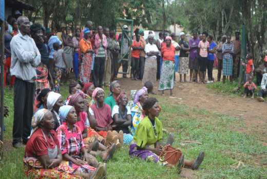
Squatters who camped at Ciagini vilage, Mwea, after being kicked out of troubled Mwea Trust Land, listen to Kirinyaga Deputy Governor Peter Ndambiri, last week. [Munene Kamau/standard]

For close to a century, battles have been fought, won and lost in what has been one of Kenya’s theatre of conflict.

To the white colonial masters, Mwea was a useless piece of wasteland, riddled with rinderpest that could not be compared with undulating plains and valleys which constituted the white Highlands, where the loyalty displayed their superiority and killed boredom by playing out their debauchery in what would later be called white mischief.

Wandered and grazed

According to Juma bin Makame, when slave trade was in vogue and raiders combed every hamlet in the highlands and lowlands in pursuit of able-bodied Africans to sell to Arabs, Mwea was devoid of any human habitation as everybody feared it.

It is in this desolate land that the Maasai wandered and grazed their animals and occasionally herded their animals to Mbonjuki and Ikindi salt lick.

Makame told the Kenya Land Commission on April 26, 1933 that 60 years earlier, Mwea had been empty grazing land which was a stomping ground for the Ndia, Mbeere and Kamba.

According to Makambe the different communities were fighting over slaves and ivory as Swahili traders traversed the country in search of weak villages to raid for stock for their Arab and European markets.

The witness, who was a government interpreter at the time, was giving evidence to determine who was legitimate owner of Mwea as people from Ndia, Murang’a as well as Embu (Mbeere) were wrangling over it.

Kerugoya Sub-district Officer at the time, HM Grant, described Mwea in 1933 as a grazing area of no economic value whose animals served as a repository for bride prices while animals for slaughter were being imported from Ukambani.

“It seems a pity that about 300 square miles of county that reputedly belong to a tribe said to be congested should produce nothing economically,” said Grant as he talked of having encountered extensive mixed settlements of the Kamba and Kikuyu.

He explained that in 1930 a total of 1,300 Kambas had settled but were evicted through a government order.

At the time, residents of Ndia regarded Mwea as theirs but to the colonial government, this parched land was of no use as it could only produce two bags of maize per acre in a good year, compared to areas such as Muguga that had a guaranteed production capacity of five bags per year.

Despite this negative publicity, when Chief Kombo Munyiri of Mbeere took the witness  stand during the Kenya Land Commission he put a strong case for his people, saying they had always resided there until they were routed out by the Maasai. 

“We have sacred groves in Mwea and continue to sacrifice there. The Maasai left after raiding our cattle. The land never belonged to them. Who has given the Mwea to Ndia. My own father fought the Maasai when he was a small uncircumcised boy”.

The narrative of Mbeere being evacuated from Mweaafter a Maasai raid was given credence by Ndegerie wa Ngenu who explained the Kisongo Maasai raided the area and at one time he witnessed hundreds of Morans being repulsed after an attack at Karawa, variously known as Bondoni.

According to Ndegerie, after the invasion which resulted with the Mbeere being driven out of Mwea, a curse (kirumi) was invoked to the effect that all community members  or their descendants must return to their land.

He told the commission: ”We want our honey barrels (hives), which are in Mwea. We have sacred groves at Mbonjuki and Njauri.

At some point it appears a truce was reached between the Mbeere and Ndia people, where a boundary was crafted to allow the two communities use Mwea amicably.

Mwiri wa Gathegwa swore before the commission,” I was present in the meeting that decided the boundary for grazing. Chief Njega wa Gioko brought two goats and I also brought two. We took an oath to the boundary beyond which the Ndia should not graze.

Evidence as fabrication

But Chief Njega dismissed the evidence as a fabrication, swearing that at no time was a boundary between Mbeere and Njega ever fixed.

“Mwea belongs to the Ndia and has belonged to them for many years. I have never heard of a fight between Mbeere and Maasai.

The only fight I know was in 1896 (the year of the eclipse) when the Ndia and Maasai combined forces and defeated the Mbeere. People from Mbeere have never crossed River Rupingazi (River Kii) for a long time,” said Njega.

According to the chief, a long time ago, Mbeere used to put their bee hives in Mwea but they would be knocked down by people from Ndia.

A peace treaty was signed where an oath was administered to end these hostilities.

Another prominent chief, Koinange wa Mbiyu told the commission that “millions of Kikuyu had gone to Ndia to fight although most of them were captured.

According to statistics from the colonial government, Koinange’s figures were exaggerated because in regard to the 1932 census, the entire Kirinyaga District had a population of 101,565 people compared to Nyeri, which had 117,867.

Fort Hall, the first Muranga District Commissioner had at around 1900 gone for a safari to Mbeere where he noticed that there were no cattle because of a rinderpest epidemic. According to Hall, the last village in Mbeere was just after Maragua River.

Earlier a boundary referred to as the Northcote Line had defined Mwea’s boundary at the point where Maraua River flows to form Tana River. However in 1927, the Kikuyu claimed that their land extended to the junctions of Thiba and Tana River.

After presentations by the various chiefs and communities concerning who should  own Mwea, the colonial government used “Solomonic” wisdom  to parcel out the contested territory.

Gichugu and by extension Ndia, who were considered part of the Kikuyu community, were given 62.90 square miles and their territory was supposed to start below Mbonjuki (lower parts of Mwea) and the boundary set  between Rupingazi River at the point where River Kii emerges from Mt kenya and goes south by River Thiba.

“The Gift of Mwea to the Kikuyu has been approved by the governor in council but owing to Legal difficulties  in conveyance the gazettement has not been effected,” concluded the Kenya LandsCommission.

Twenty years after the decision was made, the government decided to convert the communal grazing land that has been at the centre of conflict  into a rice growing irrigation scheme.

The first trials of rice growing yielded positive results in 1953 and gave the government a perfect detention camp.

When the agitation for freedom climaxed after declaration of a State of Emergency,  Mwea was used as an open detention centre where hardcore unapologetic Mau Mau freedom fighters were forced to dig canals.

After the State of Emergency was lifted, the freedom fighters who could not be accepted back into their communities were exiled in Mwea, where they were offered  and to cultivate under contract farming.