The Standard Group Plc is a
multi-media organization with investments in media platforms spanning newspaper
print operations, television, radio broadcasting, digital and online services. The
Standard Group is recognized as a leading multi-media house in Kenya with a key
influence in matters of national and international interest.
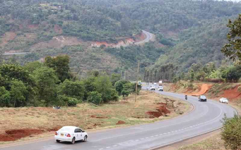
Nithi bridge in Tharaka Nithi county for a decade has been marked as a black spot. [File, Standard]
We've extensively covered the leeward side of Mt Kenya, particularly the Happy Valley and its history, including hosting one of Al Capone's bodyguards, the Chicago mobster.
My destination was Mitunguu, a small but vibrant town in Meru.You branch at Makutano (sach in Keiyo, akere keke in Luo, macemanirio in Kirinyaga) and head to Embu through Mwea and its rice paddies. Rice husks are now sold as animal feed, with heaps by the roadside.
Small towns define this side of Kirinyaga County, including Mutithi and Wamumu, one of the toughest detention centres during Mau Mau. The humidity and high temperatures must have made life very tough for inmates. That experience was easy to transfer to a juvenile school in the same locality. I rarely hear of such schools. Did we become better behaved or more tolerant of indiscipline?
Other towns have tongue-twisting names; Wang’uru, Kimbímbí, Nice, Mururi, and Pi (maths must be a very popular subject around there). The section between Makutano and Embu town is very vibrant economically, judging by the number of buildings and human and non-human traffic. Is it the rice effect and the availability of water for irrigation? Can that be replicated elsewhere?
Embu’s vibrancy is possibly an echo of its days as a provincial headquarters. The weather is less humid and colder compared to the lower parts of Kirinyaga.
One curious observation: there are lots of flats coming up on both sides of the road from Makutano to Embu, even in small towns. Why? Population growth? Devolution? Faster urbanisation?
A few kilometres after Embu town, at Kawanjara junction, better called Ena, we turned right through small towns like Nembure, Ugweri, and Karurumo before descending towards Ishiara. We avoided the Nkubu route through the infamous Nithi Bridge and more traffic...
It got hotter and more humid towards Ishiara. Trees became shorter and fewer. The lower part of Embu is drier, and the presence of goats and crops like cassava was good evidence. Despite this, it had rained, and even these lowlands were green and welcoming. Land speculators- we know you!
Tharaka-Nithi County soon welcomed us with towns like Chiakariga and Kathwana, which loudly pronounce their status as a municipality. Nkarini and Tunyai followed before Mitunguu. Tharaka-Nithi is "a haven of value addition." A catchy phrase. Evidence was not directly observable and is subject to further research.
Tharaka-Nithi is more scarcely populated compared to, say, Kirinyaga or Kiambu. Why did it carry so much political weight in the past? Let’s keep off politics for now.
What the lower part of Embu and Tharaka-Nithi lost in lower rainfall, they made up for with stunning beauty. For once, Rwanda has a competitor; there are hills everywhere. I could keep driving all day just to admire the hills. Do they have names? Mt. Kenya refused to show its beauty this day, making the hills more stunning.
Four hours gets you to Mitunguu. Though in the same climatic zone as Tharaka-Nithi, Mitunguu is in Meru County. The place is hot and humid, making it ideal for growing fruits. Mangoes, paw paws, watermelons, guavas, passion fruits, bananas, lemons, and oranges among others. Grapes? Does it surprise you that lots of fruits are imported from Egypt or South Africa and grown through irrigation in hot places? Add Southern California.
We crossed three big rivers on the way to Mitunguu. It’s strange they are not named. If dammed, these rivers could make these lowlands bloom. I saw great efforts to irrigate land. And more can be done.
The visit to where my niece is married left my head spinning. Does history really repeat itself? My father lived in Meru, at Mikinduri during WW II. Why did my niece return there to marry? Another niece married in Komothai, Kiambu, a place my dad visited 97 years ago. Is it possible that ancestors still “talk to us”? Is it mere coincidence? What do you think?
My name could be a factor. Rhymes with Imathiu, Ikiara, Iregi, Imanene, and Ikiugi among others. Should I do a DNA test to find out my real roots? Don’t be too fast to pigeonhole me. The name is also in Japan and in the Middle East. Ever noted my Japanese accent?
Stay informed. Subscribe to our newsletter
On the way back, we stopped to admire a farmer using oxen to plow his land. A young boy was having fun with the plow as the oxen drew it. You can bet why boys eventually do better than girls in sciences. I hope next time I shall find tractors plowing. Beyond harnessing water for irrigation, we need more mechanization in agriculture.
I noted on the roadside lots of colored stones, some so beautiful I carted a few pieces. This could be indirect evidence that this region hides a lot of mineral wealth. Remember where coltan is found in that neighborhood?
It seems nature is fair and generous. Dry and arid places are endowed with minerals with a few exceptions like the Congo basin. Where do you find most oil and gas? Where is coal found in Kenya?
Give credit where it’s due; our government has invested heavily in infrastructure; let’s worry about debt later. A good road network is a great economic stimulus. That was evident all the way from Nairobi to Mitunguu. Tharaka-Nithi, Embu, or Meru are closer now. The tourism sector should be one of the beneficiaries. Why did no traditional dancers welcome me to Tharaka-Nithi?
It was a day well spent. I urge my fellow countrymen to explore our beautiful country. We get visitors from other countries while the rest of the world is exploring the moon and searching for exoplanets and extraterrestrial intelligence. And we are comfortable in our villages and hamlets? Who said fun is just watching football matches and draining bottles of beer or its variants?
Let's be frank, counties have not done enough to market themselves. Why hasn't Tharaka-Nithi been marketed as "little Rwanda"? My former student, the governor of Tharaka-Nithi, must answer that question — or I may have to disclose the grade I gave him in the unit I taught him.
 The Standard Group Plc is a
multi-media organization with investments in media platforms spanning newspaper
print operations, television, radio broadcasting, digital and online services. The
Standard Group is recognized as a leading multi-media house in Kenya with a key
influence in matters of national and international interest.
The Standard Group Plc is a
multi-media organization with investments in media platforms spanning newspaper
print operations, television, radio broadcasting, digital and online services. The
Standard Group is recognized as a leading multi-media house in Kenya with a key
influence in matters of national and international interest.