State shifts focus to fault lines in bid to tame building collapses

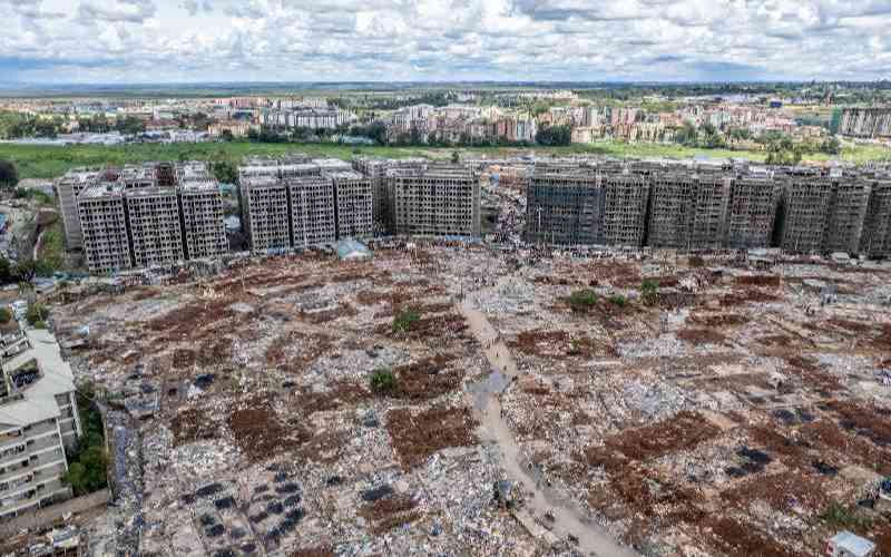
The government is developing a database that captures buildings built on or near active fault lines.

This as the State seeks a more solid solution to tame incidents of collapsing, cracking and sinking of buildings across the country.

The move, officials say, is informed by the realisation that the increased cases of buildings tumbling down and killing people in some instances could after all not always be as a result of poor workmanship or substandard building materials.

According to Lands Principal Secretary Nicholas Muraguri, the real problem might be buildings being put up on or near geological faults.

Dr Muraguri said as a result when the earth oscillates on its axis or any disturbance occurs against the fault line underground, the derivative pressure brings the buildings down.

He said the ministry has mapped areas associated with the faults as it moves to reduce the grave risks they pose on human lives and investments.

“The collapse risks present themselves not only in possible earthquakes but also in volcano eruptions, tsunamis and landslides,” said Muraguri.

He said his ministry is collaborating with that of environment to build the database that will mark all areas that are prone to such risks.

“We are concerned that we do not have accurate data on all fault lines. That we are very close to a geological fault, that is the Rift Valley, is not in dispute. We also have volcanic mountains that can erupt. We need to have this data recorded to guide our developers,” said the PS.

Some of the volcanic hotspots in the country include Mt Elgon, Mt Kenya, Longonot, Marsabit, Menengai, Nyambene Hills, Olkaria, Ol Doinyo Eburru, Elmentaita Badlands, Chyullu Hills and Mt Suswa. 

He said the working team on the project to map out the areas includes geologists, seismologists and volcanologists, who will come up with a national action plan to guide developments on all areas categorised as “geologically risky”.

Muraguri said the policy guidelines by the team will provide direction on land use and planning approaches to help local authorities as the custodians of the Building Code minimise the risks and the time it takes for individuals, communities and the government to recover from fault lines-associated disasters.

He said the multi-agency team will identify active faults in the country and record them on maps that are at the right scale to create fault hazard avoidance zones.

Such zones, the PS said, will be areas created by establishing a buffer zone on either side of the known fault trace or the identified likely fault rupture zone.

“We will recommend a minimum buffer zone that will not be open to buildings on either side of the known fault trace or likely fault rupture zone,” he said.

Further, evaluation on possible fault rupture and associated risk within each fault avoidance zone will be analysed to inform disaster response teams on best action plan to be employed should a building come down, crack or sink.

For the buildings already built on such hazard zones, Muraguri said, the data will help in disaster preparedness and also in recommending any precautionary measures to be taken by developers.

“We will use the data captured to recommend any beefing up of structural safety on such buildings and those deemed to be high risk for human occupation be condemned.

Kiambu Lands, Housing and Physical Planning Executive James Maina welcomed the new development, saying all counties should start demanding geotechnical analysis of soils in their areas before approving building plans.

“We are already doing it in Kiambu. All development plans must have a copy attached detailing the geological environment under the immediate neighbourhood of the particular land. We are faring on well since we have seen geological experts opening offices in Kiambu,” he said.

Council of Governors Deputy Chairman and Murang’a Governor Mwangi wa Iria, however, told Home&Away that the counties cannot carry out meaningful analysis on fault lines. “The country has very few geologists and even if we were to pass the burden of proving to us that the building plans that developers present to us for approval are devoid of risks associated with underground scientific pulls and pushes, we will only concede on paper value but not on evidence,” he said.

Wa Iria said the central government should take the lead in ensuring developed units have enough geologists who would then be seconded to the counties to protect the building and construction industry from the “enemy under the soil”.

Kiambu-based geological consultant Wycliffe Omuswa said the initiative is likely to encounter teething problems. “It must be appreciated that there is no technology that can be employed to prevent earthquakes damaging buildings built across faults. The best way to avert tragedies that arise from such a risk is to avoid building on fault lines,” he said.

Mr Omuswa said currently, no level of government has any policy guideline about seismic hazards despite their delegated responsibilities for subdivision and land use as well as in approving building plans.

“What we have are ad hoc disaster response and management units that jump to action on a need basis. We do not have a national plan about disasters and no central command is identifiable. You will see the military clashing with the National Youth Service or with such units like Sonko Rescue Team in times of tragedies,” he said.

“We are at zero chance when dealing with such threats that might occur from underneath earth’s disturbances.”  Omuswa said practical guidelines are urgently needed to reduce the risks associated with fault rupture.  

[email protected]  

By Titus Too 12 hrs ago
Business
NCPB sets in motion plans to compensate farmers for fake fertiliser
Business
Premium Firm linked to fake fertiliser calls for arrest of Linturi, NCPB boss
Enterprise
Premium Scented success: Passion for cologne birthed my venture
Business
Governors reject revenue Bill, demand Sh439.5 billion allocation