Premium

How to avoid chaos while building Rironi-Mau Summit highway

Traffic snarl-up at a steep climb in Gilgil along the Nakuru - Nairobi highway on December 7, 2019. [Kipsang Joseph, Standard]

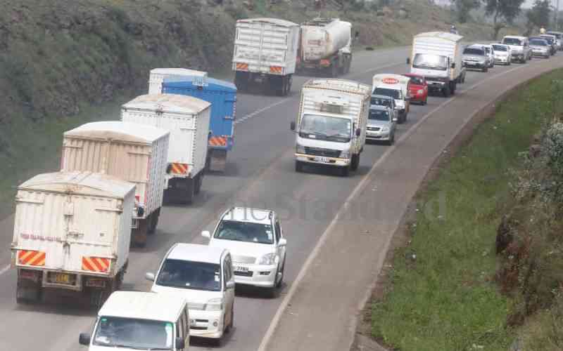
The 137km Rironi-Mau Summit road is a vital component of the Northern Corridor Network that facilitates transport and trade within the East African Community.

According to Kenya National Highways Authority, the Annual Average Daily Traffic flow through Gilgil is currently 25,000 vehicles, of which 70 per cent comprises private cars, matatus and buses.

Travelling to the western part of the country during public holidays can be a nightmare. Karai, Delamare Shop, Gilgil Weigh Bridge, Kikopey, Soysambu Farm, KPC Depot, Gate House in Nakuru CBD, Ngata and Salgaa are notable hotspots. To mitigate this challenge, the government in partnership with France, intends to widen the road to four lanes with shoulders to dual carriage standards at a cost of Sh178 billion.

The project will be the most expensive single infrastructure project since independence. Before we get excited about this mega project, let us reflect on Thika Super Highway, bypasses within the Nairobi Metropolitan Area and repair of Mombasa-Nairobi and Nairobi-Nakuru roads. Experiences and lessons are far from glorious.

Traffic snarl-ups during construction, uncontrolled development along roads and traffic jam after completion, should compel us to employ strategic thinking before commencement of road projects. We have an opportunity to do so on the new highway.

We are convinced that construction of the new road should not be limited to achieving an engineering feat. Design, construction and maintenance must be integrated with appropriate land uses and effective development control along the corridor.

We should ask several questions. First, how will normal and traffic generated during construction be managed? Second, where will Road Side Stations for long distance vehicles be located? Third, what is the link between the road and existing urban centres?

Fourth, how will uncontrolled subdivision of land along the road with resultant unsightly development be avoided? Fifth, how will the State prevent 'amoebic' emergence of non-designated urban centres along the corridor? Finally, how will aesthetic noise caused by screaming and unsightly billboards, which may be a possible cause of accidents be regulated?

I recommend short-and long-term interventions for consideration. First, during construction of the Fly Over - KPC Depot stretch, I propose that private cars, matatus and buses of up to seven tonnes from the eastern part of Nairobi and beyond destined for Nakuru, take the Thika-Kinale Forest - Flyover Road.

At Fly Over, these vehicles as well those along Rironi - Kijabe Road, may ply the C69 Fly Over- Olkalou - Dundori - Lanet Road. Second, during construction of KPC Depot - Mau Summit segment, traffic can avoid the Gate House Nakuru, CBD hotspot by plying the Dundori - Kabatini -Maili Sita - Maili Kumi - Kabarak University- Eldama Ravine -Maji Mazuri - E8 Junction.

Except Dundori - Kabatini - Maili Sita and Maili Kumi - Kabarak University segments, other roads in the loop are under KeNHA. KenHA and Kenya Rural Roads Authority should therefore partner in design, budgeting and maintenance of these roads.

This will, first, ensure smooth movement of private cars, matatus and buses to Central and North Rift, the northern parts of the Lake Basin, Uganda, South Sudan, Rwanda, Burundi and East DRC. Secondly, upon completion of construction, this loop will spur development in Kiambu, Nakuru, Nyandarua and Baringo counties. Third, success and achievements elsewhere reveal certain positive elements, which may be useful to Kenya.

For example, Stockholm Airport is a strategic installation in the European Union. In the event of calamity in Amsterdam, London, Frankfurt or Paris airports, air traffic can be redirected to Stockholm. Kenya can designate this loop as a national strategic spine in the event of any challenge on Rironi - Mau Summit Highway.

In addition, we can apply such strategic thinking in planning other components of the National Transport System. With regard to future land use, the 60km stretch between Delamare Shop and KPC Depot that cuts across ranches and conservancies with low population density requires urgent attention.

There is a possibility that registered proprietors may dispose land in blocks which although in compliance with planning standards, could, in future, be further subdivided into tiny parcels directly accessing the highway. Ideally, a land use plan should mitigate this scenario.

However, under the prevailing economic situation, such an approach is not feasible. In addition, by the time the plan is approved, construction of the road could be over, rendering the plan unhelpful. In the short term, it is more pragmatic to formulate policies on land use as provided by the Constitution and the Physical and Land Use Planning Act, 2019.

Parliament and the National Land Commission have a constitutional mandate to compel Kiambu and Nakuru County Executive Committees to formulate and approve policies to guide subdivision, prescribe hierarchy of roads, determine location and size of billboards, indicate sites for petrol service stations, malls, define minimum distances that buildings should be sited from the road reserve, including maximum heights as well as external colour of buildings in order to enhance amenity.

Business
Premium Financial hardships dampen Easter celebrations among Kenyans
Business
Premium Water PS Korir put on the spot over Sh14m dam land
Business
Premium Looming crisis as top lenders stare at Sh500b in bad loans
Business
Premium Ruto's food security hopes facing storm amid fake fertiliser scam